Strong wind gusts, flooding, and isolated tornadoes possible this evening and tonight
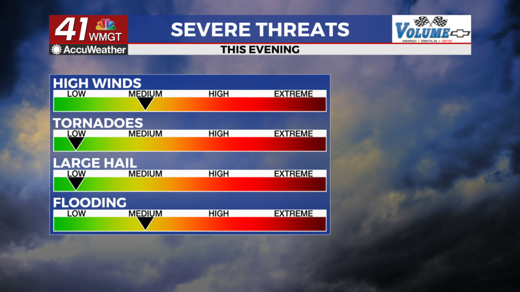
MACON, Georgia (41NBC/WMGT) – The remnants of Tropical Storm Arthur are moving into Georgia this afternoon bringing a threat of isolated tornadoes, strong winds, and flash flooding.
This Evening


Storms have begun moving through Middle Georgia and activity will persist the rest of the day and into tonight. The northern half of the region is under a Level 2 “slight” risk while the rest of the region is under a Level 1 “Marginal” risk. A Tornado Watch is in effect for the western half of the region until 11 PM tonight. Counties to the east of the current Tornado Watch have lower severe odds as the night goes on and as of now a downstream watch is not expected. While the overall tornado threat is not very high an EF-0 or EF-1 tornado is still rather dangerous, especially for folk in mobile homes.


On top of the Tornado Watch there is a Wind Advisory in effect for all of Middle Georgia until 8 AM Friday morning. Ambient wind gusts (outside of storms) will likely range from 30-40 mph through the night. The Flood Watch remains in effect until 2 AM Friday night/Saturday morning. Aside from the storms it will be another cloudy and muggy night with lows likely to stay above 70 degrees for most of the region.
Tomorrow


It will be a mostly cloudy end to the work week with another round of storms likely as a cold front moves in from the north. The severe odds should be lower than today however some hail and a few damaging wind gusts will be possible tomorrow afternoon. Temperatures will peak in the mid to upper 80s with heat indexes into the lower 90s. The wind will still be a bit breezy from the west-southwest at 5-15 mph. Gusts will likely push over 20 mph throughout the day.


Overnight the rain should subside however mostly cloudy skies will stick around. Temperatures will valley in the low 70s as the wind shifts to the west-northwest while slowing to around 5 mph. Some patchy fog is possible heading into the start of Saturday.
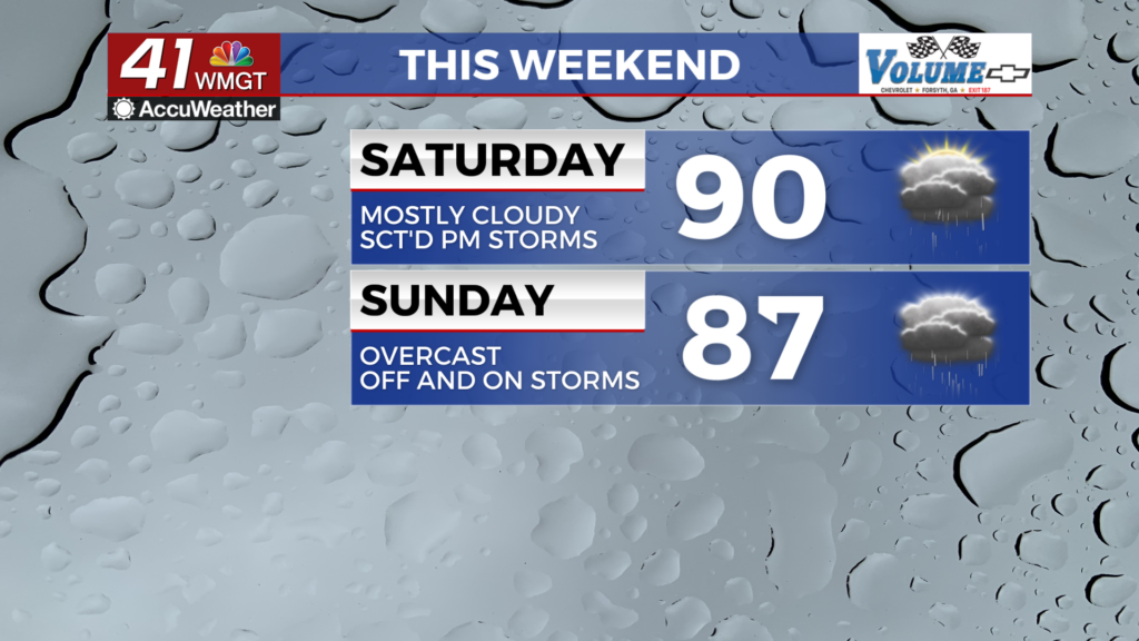
Father’s Day Weekend


The pattern will be more typical this weekend as partly cloudy skies return with isolated storms in the afternoon. Temperatures should peak around 90 degrees both days this weekend as the wind will generally flow from the west around 5 mph. Expect seasonal conditions throughout much of next week.

Follow Chief Meteorologist Aaron Lowery on Facebook (Aaron Lowery 41NBC) and X (@ALowWX) for weather updates throughout the day. Also, you can watch his forecasts Monday through Friday on 41NBC News at 4, 5, 5:30, 6, and 11 p.m.

