Flooding threat rises Thursday as tropical remnants move into the Peach State
MACON, Georgia (41NBC/WMGT) – Tropical Storm Arthur is expected to make landfall in far southeast Texas this evening before its remains push east towards Georgia tomorrow.
This Evening


Isolated showers and storms are ongoing around Middle Georgia this afternoon and a few will remain possible this evening. Rain is not expected overnight, however. Temperatures should mostly valley in the lower 70s however a couple of upper 60s are possible. Expect it to remain breezy overnight as the wind continues out of the southwest at 5-10 mph. Gusts will likely still reach to around 15 mph through the night. Overhead skies will be mostly cloudy. Tropical Storm Arthur is also expected to make landfall in southeast TX/southwest LA this evening before weakening and pushing east-northeast.
Tomorrow


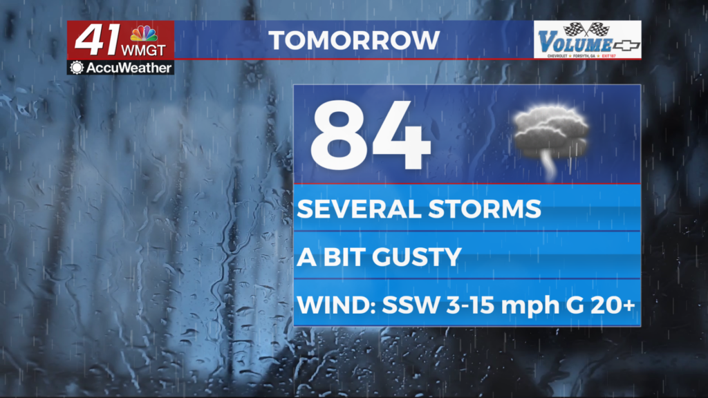
Thursday should be mostly cloudy to overcast across Middle Georgia with rain likely moving in from the west during the lunchtime hours. Once the rain moves in it will likely persist the rest of the day and into the night. A Level 1 “Marginal” threat for severe weather includes all of Georgia on Thursday with the main risk being some damaging wind gusts. A brief spin-up tornado cannot be ruled out, however. Hail is extremely rare with tropical events and thus should likely be a non-factor.


Aside from the rain expect high temperatures in the low to mid 80s as the wind flows from the south-southwest at 5-15 mph. Gusts will likely push as high as 30 mph with many ranging from 20-25 mph.


Overnight rain will continue early on before slowing some heading into Friday morning. Skies will remain overcast as temperatures again valley in the lower 70s for most of the region. The wind will remain quite breezy from the southwest with sustained speeds ranging from 7-17 mph and gusts still capable of reaching 30 mph.
Friday and Beyond


A cold front coming from the north will bring another round of thunderstorms Friday afternoon to most if not all of Middle Georgia. This will further the flooding threat leading into the weekend. The Flood Watch remains in effect for the northwestern 2/3 of the region until 2 AM Friday night/Saturday morning. A Level 1 “Marginal” threat for severe weather again includes a good chunk of Middle Georgia for Friday. Hail will be a threat with these storms as well as damaging winds. The tornado threat should be lower than Thursday, however.

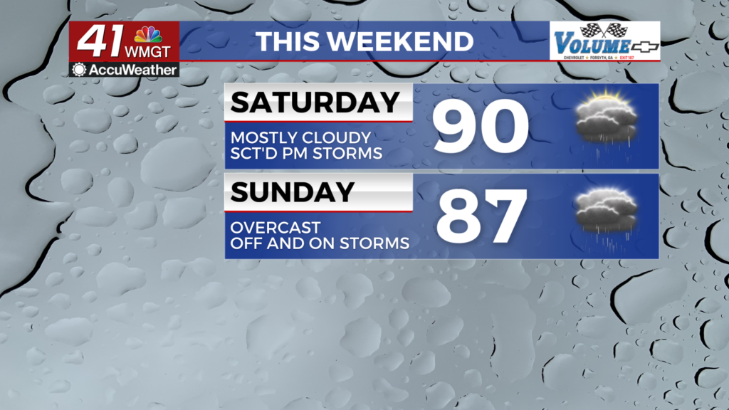
Father’s Day Weekend will see temperatures return to near average in the afternoon as isolated storm odds remain possible. Those wanting to grill should plan accordingly as both days this weekend should see close to half the region (if not more) seeing storms.

Follow Chief Meteorologist Aaron Lowery on Facebook (Aaron Lowery 41NBC) and X (@ALowWX) for weather updates throughout the day. Also, you can watch his forecasts Monday through Friday on 41NBC News at 4, 5, 5:30, 6, and 11 p.m.