Rain chances begin to climb
MACON, Georgia. (41NBC/WMGT) – Rain will be possible around Middle Georgia every day for the rest of the year.
Today


It was another warm start around Middle Georgia, only this time there wasn’t a thick layer of fog across the region greatly reducing visibility. Cloud cover hung around overnight and will be prominent through the first half of today. There will be some clearing this evening, but don’t expect all the clouds to go away; it will likely just be large pockets of sunshine. Showers are also possible through the first half of the day, but most of us in Middle GA will likely stay dry. Temperatures this afternoon will reach into the upper 70s around the region as winds blow from the south-southwest at about 8-13 mph.


Overnight tonight cloud cover will fill back in leading into Wednesday morning. Overnight low temperatures will mainly be in the mid 60s around Middle GA. The wind will also continue to blow out of the south-southwest at about 5-10 mph.
Tomorrow


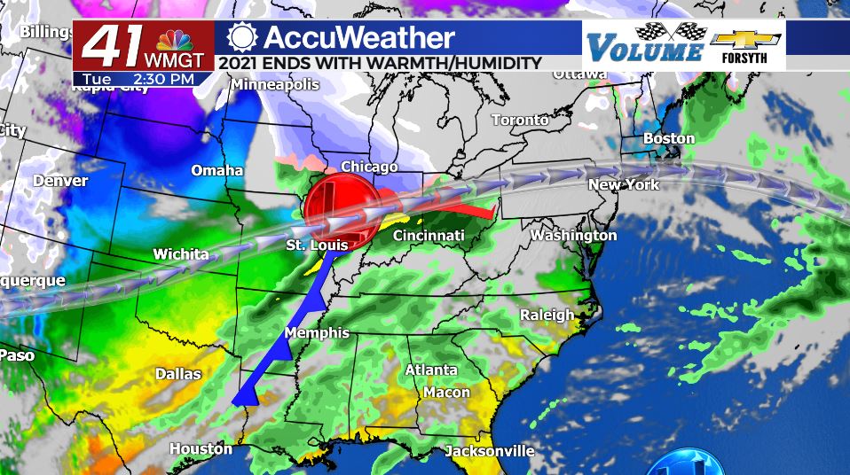
The heat and humidity continue as the middle of the week arrives. There will again be an abundance of cloud cover, but do not be surprised if there are several pockets of sunshine ahead of the late afternoon hours. Temperatures will reach into the upper 70s for most of Middle GA with one or two cities potentially eclipsing 80 degrees. Due to a weak cold front that will arrive overnight thunderstorm activity will begin to fire up during the late afternoon hours. There is currently a Level 1 Marginal Risk for severe weather for the northern and western counties of Middle GA. The primary risks will be strong winds and heavy rain, especially with sustained speeds likely to hang around 10-15 mph before the storms even arrive. The likelihood of hail and/or tornadoes is extremely slim, but unfortunately cannot be ruled out.


Overnight the rain will subside, however due to the jet stream not changing its overall pattern the wind will not shift to the northwest following the cold front’s passing. Thus, overnight lows will remain warm, staying in the 60s.
Thursday


More storms are likely Thursday afternoon, and at this time most of Middle GA is under a Level 1 Marginal Risk for that day as well. The risks will be the same; mainly wind and some localized heavy rain, but tornadoes and/or hail are highly unlikely. Temperatures will again top off in the upper 70s around the region with southwest winds continuing to blow at 10-15 mph. Overnight lows will again be in the 60s across Middle GA.

The warm pattern with PM thunderstorms will hang around into the New Year. We need to get through Wednesday and Thursday before we begin to think about the severe weather potential on Sunday. That threat will largely be driven by a cold front that will drop afternoon temperatures in the 70s into the lower 30s by Monday morning.

Follow Meteorologist Aaron Lowery on Facebook (Aaron Lowery 41NBC) and Twitter (@ALowWX) for weather updates throughout the day. Also, you can watch his forecasts Monday through Friday on 41NBC News at Daybreak (6-7 a.m.) and 41Today (11 a.m).


Leave a Reply