Warm and humid conditions stick around for final week of 2021
MACON, Georgia. (41NBC/WMGT) – A constant pattern is going to keep Georgia warm and humid for the remainder of 2021.
Today


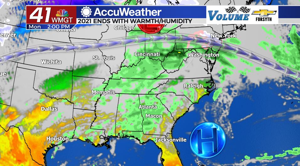
It was an extremely foggy start to the last week of 2021 with Dense Fog Advisories being issued until 9:00 AM across all of Middle GA. The humidity will go nowhere the next several days thanks to a Bermuda High that will drive southwesterly winds into Georgia for the next week. High temperatures today and most of this week will be in the mid to upper 70s across the region. We will also see a mix of sun and clouds today with a couple of opportunities for isolated showers. The wind will be rather breezy blowing from the southwest at 10-15 mph. Gusts could reach upwards of 25 mph. Rain chances are low to begin the week but will ramp up quickly once the middle of the week arrives. The zonal flow in the jet stream, however, should remain intact until the end of the week.


Overnight tonight few more clouds will begin to fill in, and the chance for rain will increase. Scattered showers are likely around Middle GA overnight and they will carry into tomorrow morning. Temperatures overnight will remain rather warm thanks to 5-10 mph southwesterly winds and plentiful cloud cover overhead, falling only into the low to mid 60s.
Tomorrow


There will likely be fog again overnight/tomorrow morning with the humidity sticking around. Visibility will be reduced further for anyone having to commute to work through early rain showers. Showers will remain possible throughout the day the southwest winds continue to blow, this time only at about 5-10 mph, however. Temperatures will reach the mid to upper 70s again during the afternoon hours despite the mostly cloudy skies overhead. A few of the showers during the afternoon may have some thunder and lightning with them, however no severe weather is expected.


Overnight expect cloud cover to break a bit as rain chances subside ahead of Wednesday. Low temperatures, however, should remain in the low to mid 60s around the region, keeping things warm as Wednesday morning arrives.
Wednesday


Thunderstorm chances are jumping up on Wednesday thanks to the formation of a new low pressure system off to the west. It will quickly make its way northeast, but not before bringing rounds of scattered thunderstorms to much of the Peach State. At this time the northern half of GA is under a Level 1 “Marginal” threat for severe weather on Wednesday with the far northwestern corner falling in the Level 2 “Slight” risk. At this time there is no severe weather risk in Middle GA for Wednesday, though that could change. High temperatures will reach the upper 70s during the afternoon with the wind still blowing from the southwest at about 5-10 mph. There will also be more clouds than sun overhead throughout the day, even though there was come clearing the night before.

Overnight the rain chances should drop a bit as things cool, but some storms could persist overnight. Low temperatures will cool a bit into the upper 50s, but the following afternoon will see highs right back in the mid to upper 70s. Thunderstorm chances will be even higher come Thursday. At this time it is too far out to make any statements about severe weather on Thursday.
The warm and humid conditions will last through the end of the year, as will afternoon shower and thunderstorm chances.

Follow Meteorologist Aaron Lowery on Facebook (Aaron Lowery 41NBC) and Twitter (@ALowWX) for weather updates throughout the day. Also, you can watch his forecasts Monday through Friday on 41NBC News at Daybreak (6-7 a.m.) and 41Today (11 a.m).


Leave a Reply