More sunshine on deck for Tuesday
MACON, Georgia. (41NBC/WMGT) – The sunny pattern continues in Middle GA as we head towards the middle of the week.
Today


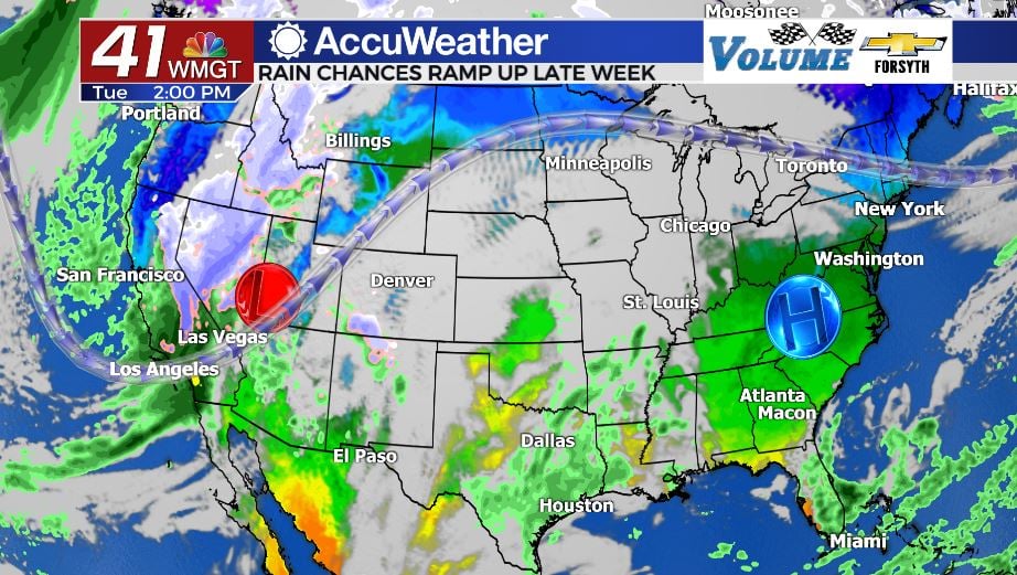
The high pressure over the southeast remains in the region, albeit slightly further east than it was yesterday. With the ridging pattern of the jet stream also still in place over the Eastern US, the sunshine will remain abundant over Georgia again this afternoon. Temperatures will reach values slightly higher than yesterday, but it’s not going to be overly noticeable. We’ll be reaching the mid to upper 60s around the region, and only a few high level cirrus clouds are expected to populate the skies. Rain is not expected during the daylight hours either. Also, like yesterday, the wind will predominantly blow from the northeast at around 5 mph, keeping things cool.


Overnight tonight is when changes begin to happen, however. Clouds will fill in from the south beginning with high level clouds, however a few mid and low level clouds will build too. Showers are unlikely for most of Middle GA, however a couple of southern counties such as Telfair or Wilcox will have an opportunity for a stray shower overnight. The wind will continue to blow out of the northeast, however thanks to the added cloud cover low temperatures for most of the region should only fall into the lower 40s vs the low and mid 30s of the past couple of nights.
Tomorrow


The fully sunny skies will give way to a mix of sun and clouds beginning on Wednesday as the next storm system begins to form off to the west. A few isolated showers will be possible around Middle GA throughout the afternoon, however nobody is guaranteed to see rain. The wind will predominantly blow out of the east-northeast, shifting ever so slightly to the south as the day progresses. Partly cloudy skies will allow temperatures to warm into the upper 60s, however it is unlikely anywhere in the region cracks 70.

Overnight into Thursday even more clouds will fill in as the next system continues its approach. A few showers lingering from the day will be possible early as the wind blows directly out of the east at around 5 mph. The abundance of overnight cloud cover will allow low temperatures to climb into the upper 40s and lower 50s, almost 20 degrees warmer than just two nights before.
Thursday and Beyond

Thursday will again see a mix of clouds and sun, only now the winds will be blowing from the south-southeast, adding plenty of heat and moisture to the Georgia atmosphere. High temperatures will respond by climbing into the lower 70s around Middle GA despite the added cloud cover. There is also a higher chance for showers on Thursday with about 20-30% of the region expected to receive at least a bit of rain. Low temperatures heading into Friday will fall into the low to mid 50s around the region.

Friday will see more cloud cover however the rain chances are expected to drop as a cold front stalls out over Tennessee and becomes a stationary front. The wind will continue to blow out of the south-southeast as temperatures rise into the mid to upper 70s around the region. Low temperatures will also continue to warm, only falling into the upper 50s under mostly cloudy skies.
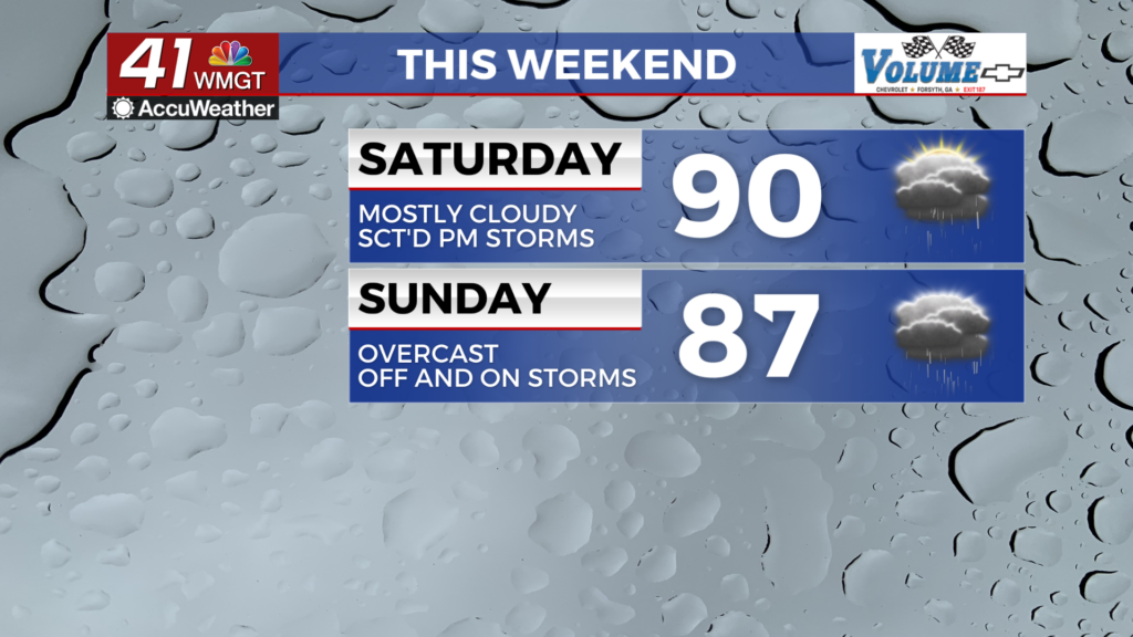
The weekend will see an increase in rain chances as the stationary front moves south slightly and a ridging pattern in the jet stream over the Atlantic slowly breaks down. High temperatures will reach the upper 70s on Saturday and the upper 60s on Sunday. Both days will see an abundance of cloud cover.

Follow Meteorologist Aaron Lowery on Facebook (Aaron Lowery 41NBC) and Twitter (@ALowWX) for weather updates throughout the day. Also, you can watch his forecasts Monday through Friday on 41NBC News at Daybreak (6-7 a.m.) and 41Today (11 a.m).


Leave a Reply