Isolated showers possible Thursday
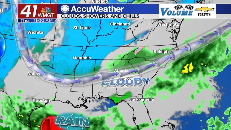
MACON, Georgia. (41NBC/WMGT) – Cloudy conditions have moved into the Peach State and some isolated showers will be possible in parts of Middle GA.
Today


Cloud cover increased drastically during the overnight hours Wednesday into Thursday morning. Rain moved into northern GA during the overnight hours as well, however rain has been scarce in Middle GA to this point. A blanket of clouds will remain over the majority of the region throughout the day Thursday with pockets of sunshine being limited to the southernmost counties later this afternoon. Temperatures for most of the region will top off in the mid to upper 50s; the 60s will only be seen in the southern counties that see some sun later today. Our rain chances will be highest before noon today with isolated showers reserved for the northern counties of the region. Rain totals for Middle GA heading into Friday should remain below .1 inches as any showers that pass through will bring light rain and not last long. Low temperatures overnight will fall into the low to mid 40s around the region.
Tomorrow


Friday will see the blanket of clouds remain over Middle GA. The best chance for rain, however, will shift to the south. The low pressure system will begin to creep along the gulf coast and northern Florida before moving along the southeastern US coast heading into Saturday. This will keep cloudy conditions over the majority of the Peach State along with bringing heavy rain to the southeastern portion of the state. For us in Middle GA, the rain chances will be highest in the southeastern counties with rain activity being limited to isolated showers further north. Some locations such as Forsyth or Butler may see no rain Friday or Saturday while locations such as McRae or Dublin could receive upwards of half an inch during the same time period. Temperatures Friday afternoon will top off in the upper 50s with a couple of locations cracking the 60 degree mark. Low temperatures will fall into the low 40s.
Saturday

The cloudy skies will remain through Saturday as the low pressure system trudges along the Georgia Bight. This will bring widespread rainfall to Southeast GA and scattered showers to the middle of the state. High temperatures will increase slightly from Friday, mainly topping off in upper 50s and lower 60s. Rain chances will taper during the evening hours with cloud cover breaking overnight. Low temperatures will fall into the upper 30s and lower 40s ahead of Sunday morning.

Sunday will see the return of sunny skies to Georgia as wind returns to the north-northwest. Despite the wind directions high temperatures will return to the mid and upper 60s thanks to the sunny conditions. Temperatures will continue to increase into next week, climbing back into the 70s as sunshine remains in the area through at least next Wednesday.

Follow Meteorologist Aaron Lowery on Facebook (Aaron Lowery 41NBC) and Twitter (@ALowWX) for weather updates throughout the day. Also, you can watch his forecasts Monday through Friday on 41NBC News at Daybreak (6-7 a.m.) and 41Today (11 a.m).


Leave a Reply