Cloudy skies to take over as widespread rainfall moves in midweek
MACON, Georgia. (41NBC/WMGT)- Rain chances ramping back up; heaviest expected Wednesday
Today


Middle Georgia kicked off Tuesday with an abundance of cloud cover and a few spotty showers. This theme will be prevalent over the next few days as low pressure moves through the far Southeastern US. For today, temperatures will not fall much from yesterday despite mostly cloudy skies throughout the day. Highs are forecast to be in the lower 90s once again with a few locations remaining below that 90 degree mark. Storm chances are higher than yesterday with scattered showers and storms firing up during the late lunchtime hours. There will be a few pockets of sunshine here and there, but don’t expect to see a lot of it. Rain totals for today are not very high, but a good portion of Middle Georgia will likely see some precipitation this afternoon and evening. Showers could carry into the overnight hours but should subside before midnight. Low temperatures are forecast to be in the lower 70s.
Tomorrow


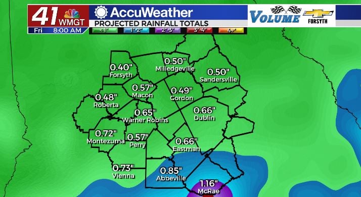
Wednesday is the wet day for this week. Cloudy skies will dominate from sunrise until sunset with storms firing up during the lunchtime hours. Unlike today, however, they are going to be widespread rather than scattered. Grab your raincoat as you head out the door as many of the storms tomorrow afternoon will have localized heavy rainfall. High temperatures are forecast to be a bit cooler thanks to the rain and cloud cover, however humidity will be higher. Temperatures will top out in the mid to upper 80s around Middle Georgia tomorrow afternoon with lows in the lower 70s. Storms will persist into the overnight hours, with multiple rounds expected to carry into Thursday morning. The cloud cover will also persist into Thursday morning.
Thursday and Beyond
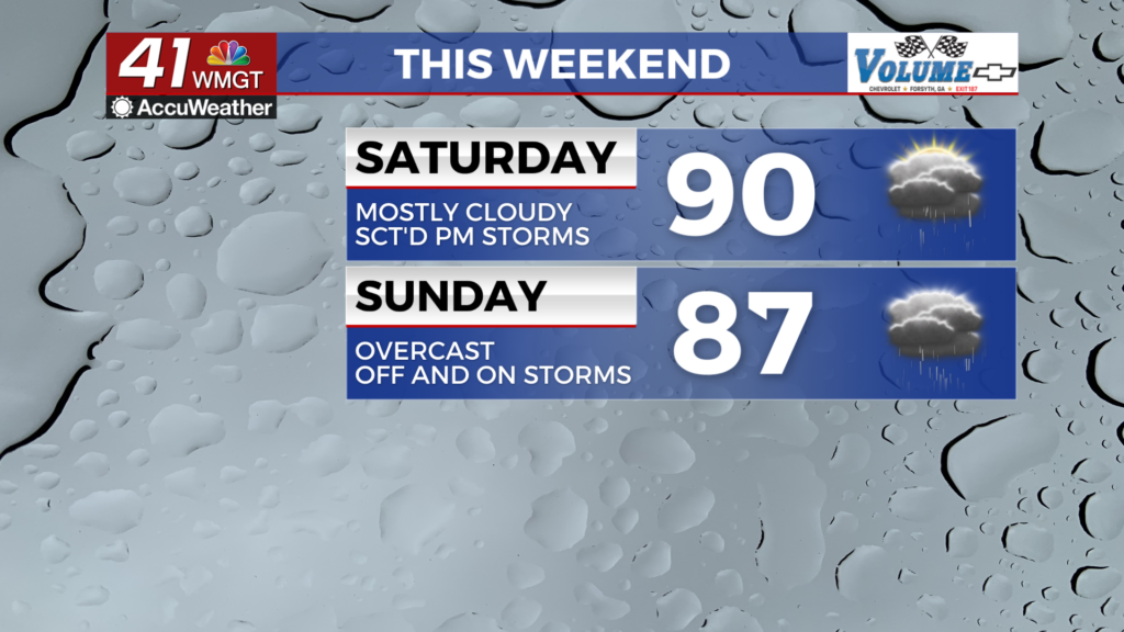
Thursday morning will begin with some showers for parts of Middle Georgia; especially the southern counties as the low pressure pushes into the Atlantic. Storms will remain possible during the afternoon hours as temperatures climb into the upper 80s under mostly cloudy skies. As the day progresses, however, the clouds will begin to break over the northern half of the region. Cloud cover will continue to dwindle through the overnight hours into Friday morning. Friday should bring the return of some sunshine and warmer temperatures with a chance for isolated storms during the afternoon and evening. Expect similar conditions on Saturday with rain chances ramping back up again on Sunday.


Follow Meteorologist Aaron Lowery on Facebook (Aaron Lowery 41NBC) and Twitter (@ALowWX) for weather updates throughout the day. Also, you can watch his forecasts Monday through Friday on 41NBC News at Daybreak (6-7 a.m.) and 41Today (11 a.m).


Leave a Reply