The start of Spring brings warmer temperatures
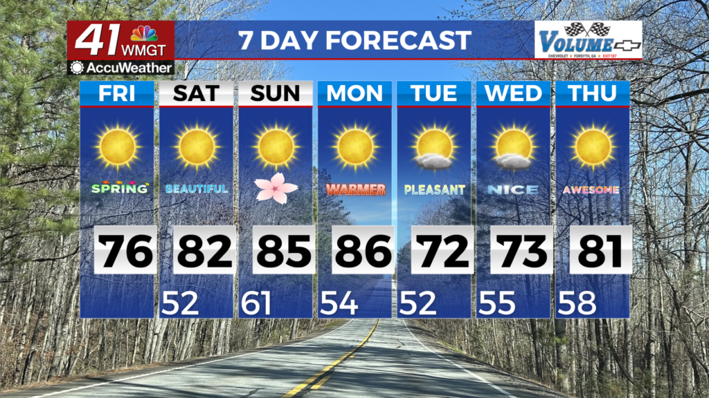
MACON, Georgia (41NBC/WMGT) – The main story continues to be the dry conditions and warming temperatures. Mild lows in the 40s Friday morning will warm into the mid to upper 70s 


(which is 6 to 12 degrees above normal) by the afternoon. By Saturday, temperatures will only drop into the 50s. Dew points will also gradually increase during this time as well, with afternoon relative humidity a touch higher than today (upper 20s and 30s) aside for a few pockets in East Middle Georgia that could see a few hours of 25 percent. Beginning Saturday, surface high pressure is centered over the Gulf with a weak wave moving southeast out of the Kentucky/Tennessee area. This wave is very weak and dries out considerably as it pushes into North Georgia. This ridge over the Gulf keeps warm southwest flow at the surface helping to warm things up. High temperatures return to the 80s across much of the area over the weekend. At this time, Sunday appears to be the warmest day of the next seven, with highs in the mid to upper 80s, which could be near record levels. Morning lows climb to the mid to upper 50s. Between the dry northwest flow, subsidence from the southwestern U.S. ridge, the ridge itself and the storm track remaining off to the north, rain chances will remain low through the middle of next week. Temperatures will cool off a bit Monday and Tuesday as a dry cold front sweeps south through the state. For now, only expect increased cloud cover from this front and temps to dip back down into the 60s and 70s instead of the 80s Sunday.