Scattered storms expected Saturday afternoon as a cold front blows through
MACON, Georgia (41NBC/WMGT) – An incoming cold front will bring storms Saturday afternoon and powerful chilly wind on Sunday to bring temperatures back towards winter norms.
This Evening


Mostly cloudy skies will stick around Middle Georgia along with wind out of the south-southwest. Gusts will range in the 15-20 mph range before slowing some overnight. A stray shower or two will be possible through the evening and overnight though this should be limited to the northwestern reaches of the region. Low temperatures ahead of Saturday morning will be in the low to mid 60s, or more than 20 above the average for this time of year. Patchy fog will be possible however the wind gusts may limit this potential.
Tomorrow


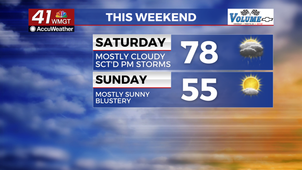
The first half of the weekend will continue the warm, muggy, and cloudy pattern that has been seen throughout the week. Temperatures will rise into the upper 70s and possibly lower 80s in the warmest spots. The wind will be rather strong out of the southwest at 10-20 mph with gusts pushing as high as 25-30 mph


During the afternoon the cold front will finally arrive bringing some showers and storms. The northwestern half of Middle Georgia is currently under a Level 1 “Marginal” threat for severe storms while the rest of the region is under a Level 0. A few damaging wind gusts are the main concern with this system, however the risk for that will drop as the line pushes southeast through the region. This is thanks to the low pressure driving the system being located well to the north over the Eastern Great Lakes/New York.


Overnight the wind will shift from the southwest to the northwest following the frontal passage. Overnight lows will primarily be in the mid to upper 40s ahead of Sunday morning. Temperatures just after midnight will be in the low-mid 60s though, good for the actual high temperatures for Sunday.
Sunday and Beyond


Sunday will be blustery as the wind howls from the northwest at 10-20 mph with gusts potentially reaching over 30 mph through the afternoon. The actual highs for the day will be shortly after midnight Saturday as mentioned above, however the afternoon will have relative highs in the mid 50s. Overnight will see temperatures continue to plummet all the way into the mid to upper 20s, so the dripping of faucets is suggested overnight into Monday (and again Monday night into Tuesday) to avoid potential plumbing issues. Bring any pets or plants inside as well. Next week will be much cooler as high temperatures will be cooler than low temperatures to end the current week.

Follow Chief Meteorologist Aaron Lowery on Facebook (Aaron Lowery 41NBC) and X (@ALowWX) for weather updates throughout the day. Also, you can watch his forecasts Monday through Friday on 41NBC News at 4, 5, 5:30, 6, and 11 p.m.


