Cooler temperatures and plenty of rain likely for the first weekend of August
MACON, Georgia (41NBC/WMGT) – An incoming cold front will stall out just south of Middle Georgia over the weekend, dropping temperatures but bringing plenty of rain opportunities in the process.
This Evening


Cloud cover is increasing through the afternoon as storm chances become more widespread into the evening. The entirety of Middle Georgia is under a Level 1 “Marginal” threat for severe storms as the most organized ones may bring damaging wind gusts or perhaps some hail. It is First Friday, however the storms may lead to some cancellations of a few events. Rain gear will be needed by anyone going out on this Friday night.


Rain will remain possible into tonight as cloud cover will be plentiful through the night. Expect low to mid 70s for low temperatures around Middle Georgia heading into the start of the weekend. Wind will be light and variable.
Tomorrow


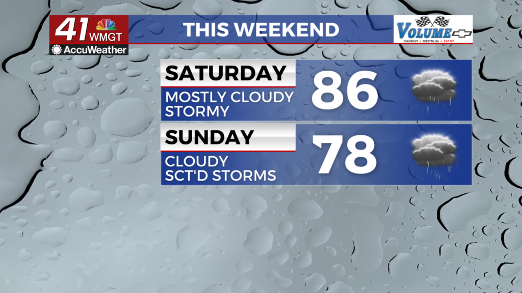
Saturday will be a cooler day as mostly cloudy skies are likely during the sunlight hours. Highs are likely to reach into the upper 80s for most of the region with the hottest spots possibly cracking 90. Heat indexes will still largely be in the mid to upper 90s, however. Wind will be light and variable.


Storm activity should begin in the late morning/lunchtime hours, becoming more widespread through the afternoon. As of now the southwestern counties of the region are included in a Level 1 “Marginal” threat for severe weather. This is due to the possibility for a few organized storms bringing some damaging wind gusts. Flash flooding could also be a possibility in areas that see multiple storms.


Overnight some rain may continue as cloud cover hangs around. Wind will be light from the east at around 5 mph. Lows will be in the upper 60s and lower 70s, finally dropping below average for the first time in a few weeks.
Sunday and Beyond


Sunday is likely to be overcast with highs in the lower 80s and possibly upper 70s. Wind will be light from the east-northeast at 5-10 mph with storms beginning during the lunchtime hours, continuing through the afternoon and evening. As of now severe storms are not expected, however the issuance of a Level 1 “Marginal” threat cannot be ruled out in the event of a few damaging wind gusts.


The cooler and cloudier pattern will carry into the new week with rain chances remaining elevated. Temperatures should stay below average while this pattern remains in the area. The elevated rain chances should help limit the returning drought around the region as well.

Follow Chief Meteorologist Aaron Lowery on Facebook (Aaron Lowery 41NBC) and Twitter (@ALowWX) for weather updates throughout the day. Also, you can watch his forecasts Monday through Friday on 41NBC News at 4, 5, 5:30, 6, and 11 p.m.