Scattered storms tonight; isolated storms tomorrow
MACON, Georgia (41NBC/WMGT) – An incoming cold front will spur on a round of storms for Middle Georgia today and a few more tomorrow.
This Evening


Continuing through the evening skies will stay mostly cloudy as storms become more widespread. A Level 1 “Marginal” risk for severe storms includes the northernmost counties of the region. This risk is for a bit of hail or a few strong winds.


Lows will mainly be in the lower 70s accompanied by light winds from the southwest.
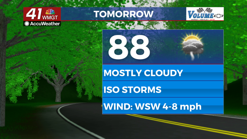
Tomorrow


Wednesday is also expected to be mostly cloudy and should see some isolated storms over the latter half of the day. Highs will reach the upper 80s and lower 90s with real feels in the mid to upper 90s. Wind will be light from the west-southwest.


As of now there are no areas highlighted for severe storms tomorrow, however the most intense storms could still have some small hail or relatively strong gusts.


Overnight will be partly cloudy with lows expected in the lower 70s and upper 60s. Wind will be light and variable. A few storms may linger early.
Thursday and Beyond


Rain odds will drop Thursday as the cold front that brought the scattered storms will begin to clear the area. Temperatures will climb to finish the week, however, and sunshine will become more abundant. Expect temperatures to climb through the weekend and into next week.

Follow Chief Meteorologist Aaron Lowery on Facebook (Aaron Lowery 41NBC) and Twitter (@ALowWX) for weather updates throughout the day. Also, you can watch his forecasts Monday through Friday on 41NBC News at 4, 5, 5:30, 6, and 11 p.m.