Isolated storms likely this evening; more rain tomorrow
MACON, Georgia (41NBC/WMGT) – Rain chances are up across Middle Georgia to begin the new week.
This Evening


A partly cloudy afternoon will see isolated storms around Middle Georgia through suppertime and into the overnight hours. The most intense storms could bring a bit of hail or strong wind gusts. Overnight expect partly cloudy skies with storms tapering off after midnight Lows will largely be in the lower 70s ahead of Tuesday’s sunrise. Wind will be light from the southwest.
Tomorrow


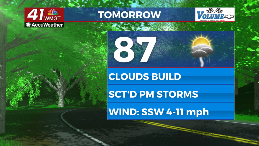
A cloudier day is likely Tuesday with more widespread rain odds likely over the latter part of the day. Temperatures will reach the upper 80s and lower 90s with real feels reaching the upper 90s and lower triple digits. Wind will be light from the south-southwest at 5-10 mph.


As of now the northern parts of Middle Georgia are included in a Level 1 “Marginal” threat for severe weather. This is due to the possibility for the strongest storms to bring some hail or damaging wind gusts.


Overnight a few storms will linger past midnight with a slim chance for a shower to hang around towards the sunrise on Wednesday. Lows will mainly be in the lower 70s however a few upper 60s cannot be ruled out. Wind will be light from the southwest.
Wednesday and Beyond


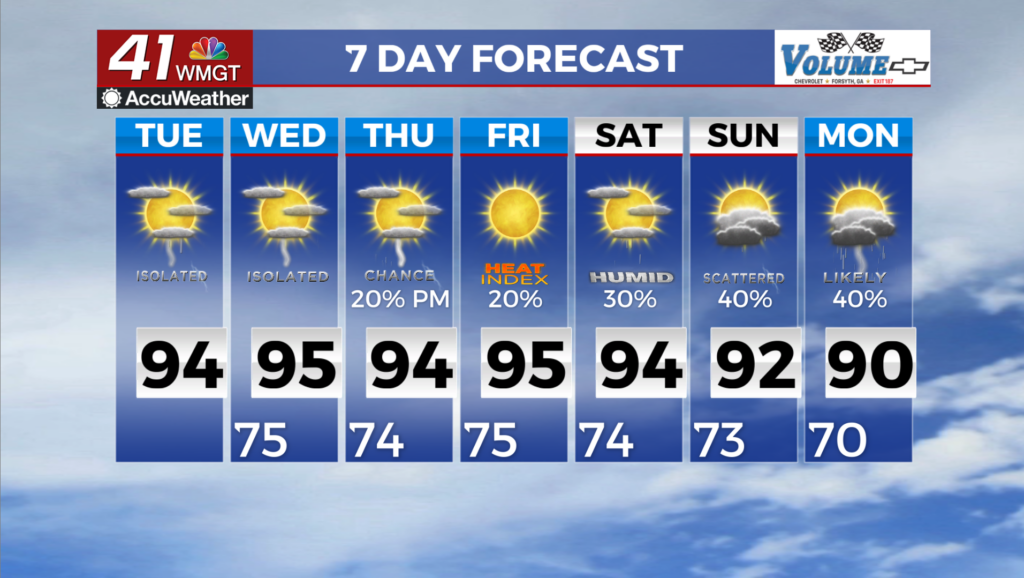
Another decent round of storms is likely Wednesday as a cold front will move into the region from the northwest. This will ultimately lead to a drop in rain odds over the final two days of the work week. This should correlate well with folks celebrating Independence Day on Friday with fireworks displays.
Watching the Tropics

There hasn’t been too much to discuss in terms of the Tropics yet, and that is to be expected. That said, the NHC is monitoring a disturbance over the Gulf south of the Florida panhandle. It has a 20% chance to develop into a depression within the next 7 days. Georgians need not worry about this as the aforementioned cold front will keep it to the south/east.

Follow Chief Meteorologist Aaron Lowery on Facebook (Aaron Lowery 41NBC) and Twitter (@ALowWX) for weather updates throughout the day. Also, you can watch his forecasts Monday through Friday on 41NBC News at 4, 5, 5:30, 6, and 11 p.m.