Sunny skies return Tuesday
MACON, Georgia (41NBC/WMGT) – Sunnier conditions will be back for Middle Georgia after a cloudy weekend and start to the week.
This Evening


Storm activity will subside ahead of suppertime tonight, however expect clouds to linger into the overnight hours. It will be a cooler night with low temperatures expected in the upper 40s and lower 50s, or almost 15 degrees below lows from Sunday night/Monday morning. Expect wind from the northwest at 5-10 mph. Gusts could push 20 mph through the night. Skies should be mostly clear by Tuesday morning.
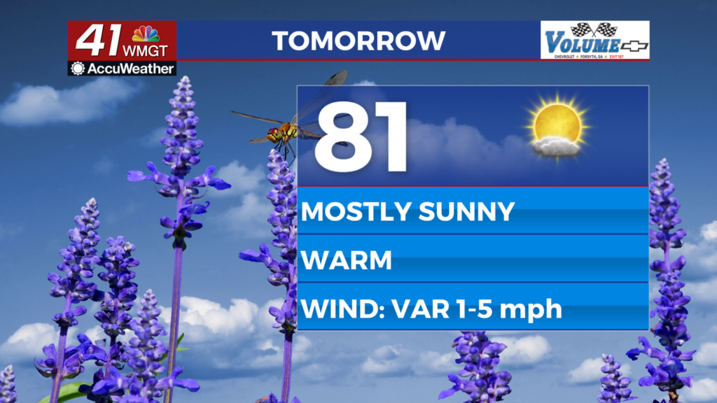
Tomorrow


The sunshine will be back and temperatures will be quite warm despite the cold front that brought storms Monday. Highs will be in the low to mid 80s around the region with wind shifting from the northwest to the southwest at around 5 mph.


Overnight will be mostly clear with low temperatures expected in the upper 50s. Some fog will be possible ahead of Wednesday morning as the overnight wind flows from the southeast at 5-10 mph.
Wednesday and Beyond


A major pattern shift is expected with the flip of the calendar as record highs could be possible over the back half of the week. It will feel like summer with highs reaching into the 90s and lows staying in the mid to upper 60s. There will be plenty of humidity and as a result expect more mosquitos to emerge in the evenings/mornings. Conditions will remain hot and humid into the first weekend of April.

Follow Chief Meteorologist Aaron Lowery on Facebook (Aaron Lowery 41NBC) and Twitter (@ALowWX) for weather updates throughout the day. Also, you can watch his forecasts Monday through Friday on 41NBC News at 4, 5, 5:30, 6, and 11 p.m.