Sunshine and above average temperatures return Tuesday
MACON, Georgia (41NBC/WMGT) – High pressure moving in behind Monday’s cold front will lead to plenty of sunshine around the Peach State.
This Evening


The clouds from today will stick around through the evening and into tonight, however skies by tomorrow morning should be clear. Expect lows in the mid 40s for much of the region with accompanying wind flowing in around 5 mph from the north-northwest. A stray shower cannot be ruled out early, however rain really isn’t expected overnight.
Tomorrow


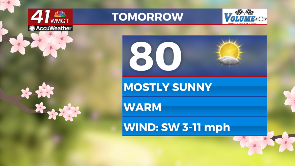
Temperatures will pick up where they left off Sunday afternoon as highs push into the 80s for several Middle Georgia locations Tuesday afternoon. Thanks to high pressure the wind will shift back to the southwest early on Tuesday afternoon. Expect speeds of 5-10 mph with the occasional, gust up to 20 mph.


The night will be clear and mild with lows expected in the mid to upper 40s across the region. Wind will be calm. Some patchy fog cannot be ruled out.
Wednesday and Beyond


A second cold front will move through Wednesday, increasing the wind and leading to slightly cooler conditions later in the week. Highs will mainly be in the 70s after that front vs the 80s. Overnight lows could dip back into the lower 40s. Expect the wind to be stronger Wednesday as well before it slows more later this week.

Follow Chief Meteorologist Aaron Lowery on Facebook (Aaron Lowery 41NBC) and Twitter (@ALowWX) for weather updates throughout the day. Also, you can watch his forecasts Monday through Friday on 41NBC News at 4, 5, 5:30, 6, and 11 p.m.