


Severe storms expected overnight Saturday
MACON, Georgia (41NBC/WMGT) – An incoming cold front will bring severe storm odds to Middle Georgia overnight Saturday into Sunday.
This Evening
It’s been a mostly cloudy end to the week around Middle Georgia with temperatures and humidity climbing ahead of the weekend. Wind tonight will be slightly breezy before it picks up a lot more tomorrow afternoon. It will flow from the south-southeast at 5-10 mph. Low temperatures will be in the mid to upper 50s across most of the region. Some patchy fog will be possible ahead of tomorrow morning.
Tomorrow
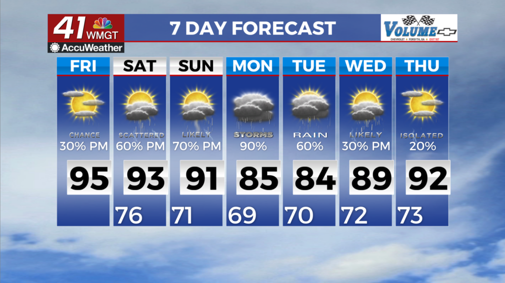
A partly to mostly cloudy day is anticipated Saturday and it will get quite warm and windy. Highs will be in the low to mid 80s across the region with dewpoints likely rising into the mid to upper 60s. Wind will flow from the southwest-southeast at 10-20 mph, gusting anywhere from 25-35 mph. A spotty shower or two will be possible in the evening, but rain odds should stay low until after midnight.
Tomorrow Night: The Severe Window
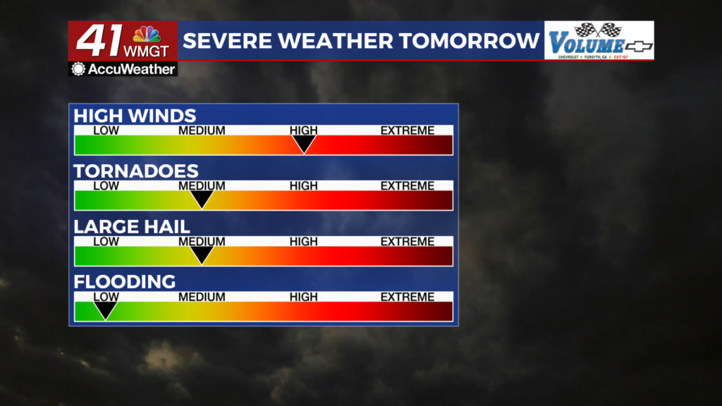
All modes of severe weather will be possible for Middle Georgia tomorrow night after midnight. A Level 3 “Enhanced” risk includes the western 2/3 of the region with a Level 2 “Slight” risk including the rest.
While all modes of severe weather are possible, the main threat will be strong winds while the most dangerous threat will be tornadoes. These may not be limited to just the brief spin-up variety either (the Significant Tornado Threat means that there are 10% odds of an EF2 or greater tornado within 25 miles of a point). SPC has 10% or greater odds for most of Middle Georgia to see a tornado. The western 3rd of the region could also see wind gusts in excess of 80 mph (that’s Category 1 Hurricane strength). The hail threat is the lowest but cannot be ruled out. No significant hail is expected, however.
Storms will likely begin to move into Middle Georgia after midnight Saturday night, especially in that 2-4 am range. Winds will already be rather strong by the time that happens (gusts will be over 40 mph in many locations). Middle Georgians need to have a way to get warnings whether that be through the 41NBC app, a weather radio, or some other method. The line of storms should be clearing the region during or shortly after the sunrise Sunday morning.
Sunday and Beyond
Sunday will see plenty of wind from the west-southwest once the storms clear out. Expect the clouds to clear out through the afternoon as temperatures peak in the upper 70s for most of the region. Clear skies expected overnight and into Monday with low temperatures in the mid to upper 40s. There will be plenty of sunshine to begin next week as well as plenty of wind.

Follow Chief Meteorologist Aaron Lowery on Facebook (Aaron Lowery 41NBC) and Twitter (@ALowWX) for weather updates throughout the day. Also, you can watch his forecasts Monday through Friday on 41NBC News at 4, 5, 5:30, 6, and 11 p.m.
