Wet weekend ahead as heat relief nears
MACON, Georgia (41NBC/WMGT) – Rinse and repeat as summertime continues with a few showers and thunderstorms possible and hot temperatures. As is normal for this time of the year, a 


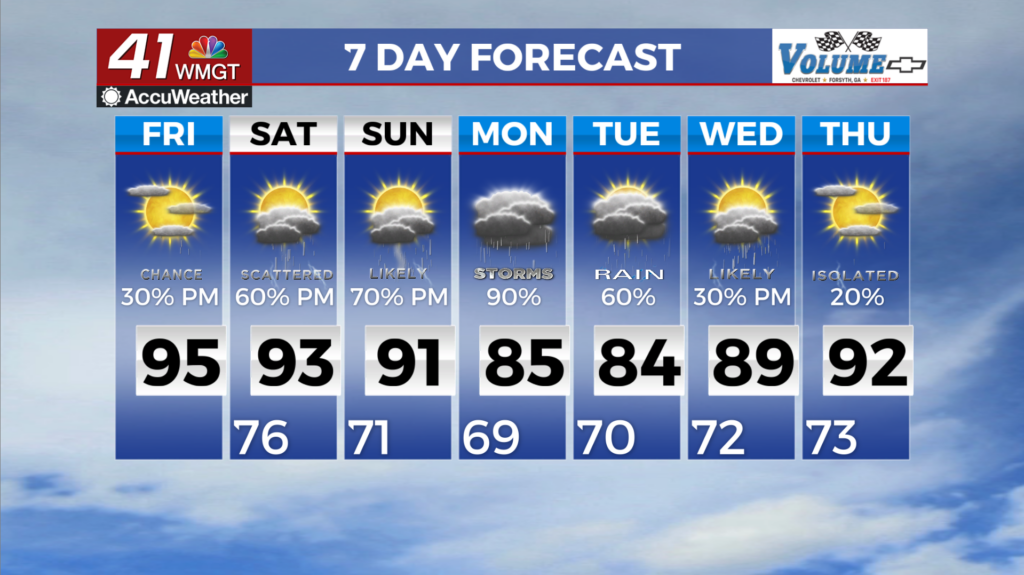
strong area of high pressure churns over the Atlantic and keeps the southeast in an open warm sector, increasing diurnally driven convection each afternoon. Not much coverage is expected today, but a few showers and typical summer thunderstorms are possible. The best chances are in the northwest portion of Georgia, with chances quickly decreasing southward into Middle Georgia. The main hazard from any storm should be damaging winds, especially in the northern part of the state. As for the heat, the temperatures remain hot in the short term. Low to upper 90s will span


north to south with the hotter temps towards Middle Georgia. Since we will remain in the open warm sector and an abundance of moisture is still lingering, hot heat indices are still on track. Triple digits for today and Saturday, with a smattering of 105-108 degrees are possible towards southeast Georgia. Because of this, another Heat Advisory is in effect through 8 PM tonight for the 
southeast portion of the state. It’s gonna be a rainy weekend. Not a total washout, however if you have outdoor plans, you might want to reconsider. Saturday afternoon, the chances of thunderstorms become likely across northern Georgia before spreading to all of the coverage area by Sunday afternoon. A few storms could be strong to severe with the main threat being damaging winds, but the likelihood for widespread severe weather is not too concerning. The rain-cooled environment and northwest flow will give us a break from the heat, with highs in the mid to upper 80s by Sunday which will linger through the start of the work week. By next Wednesday, the heat will start to build again as a Bermuda High reestablishes and tropical moisture builds back in.