
Warmer temperatures arrive for Valentine’s Day
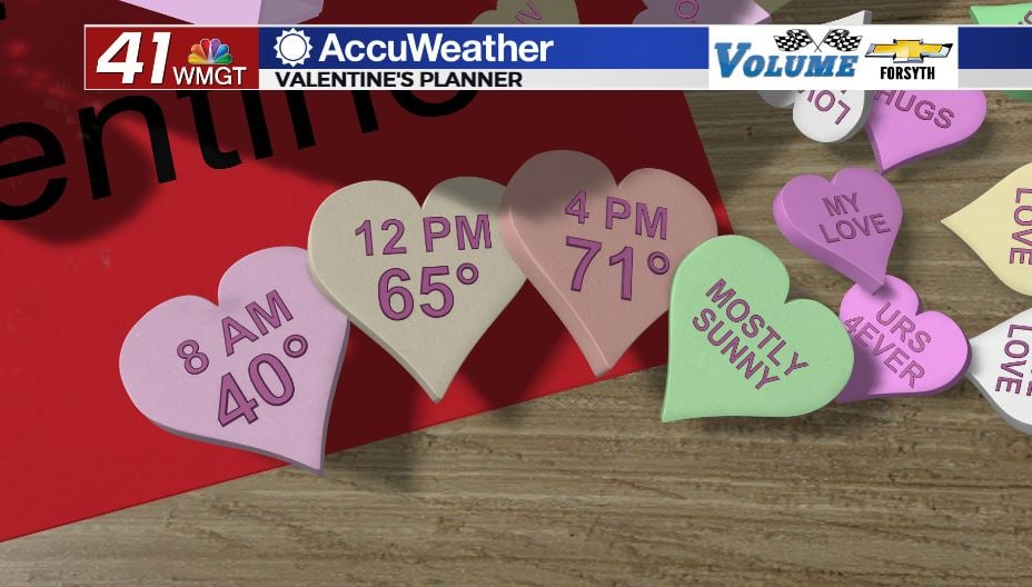
MACON, Georgia (41NBC/WMGT) – Temperatures will climb into the 70s Tuesday afternoon.
Today
Middle Georgia will enjoy another lovely afternoon for Valentine’s Day 2023. While some cirrus clouds may populate the skies, temperatures will reach into the lower 70s across the region during the late afternoon hours. Winds will blow from the south-southeast at about 3-10 mph. Gusts could push as high as 15 mph. Cirrus clouds from the afternoon will likely clear the area for the most part heading into the evening hours.


Some scattered cirrus clouds along with a few mid-level clouds are likely to pass through Middle Georgia overnight tonight. Winds will shift more to the south while maintaining the same speed from the afternoon. Temperatures will largely drop into the mid 40s with dew points in the lower 40s. Widespread fog is unlikely to begin our Wednesday, however a couple of spots could see some patchy fog.
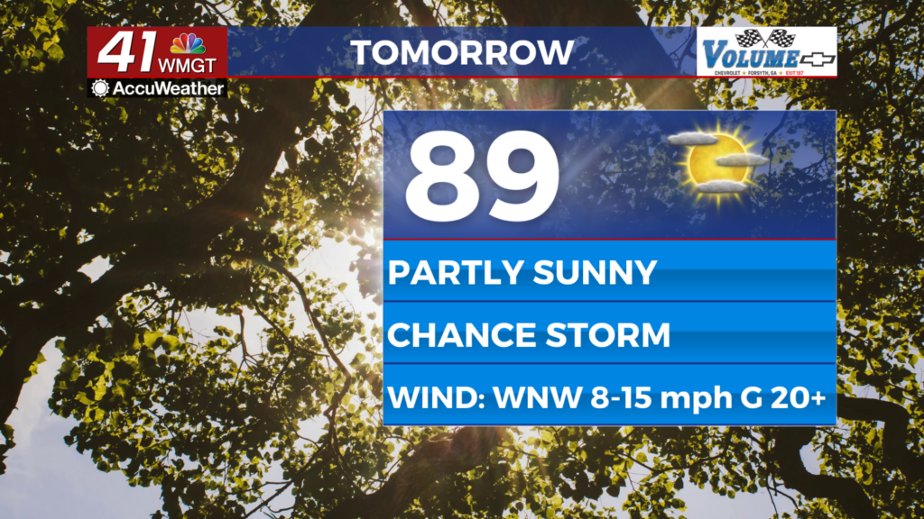
Tomorrow
Middle Georgia will see more added cloud cover during the afternoon on Wednesday. In fact, the far northwestern counties (Monroe, Crawford, Taylor) may see a couple of small, isolated showers during the early parts of Wednesday. Rain chances for those spots will dwindle in the afternoon as temperatures rise more into the mid 70s. Rain is unlikely anywhere else in the region tomorrow as the first incoming cold front will stall out to the north. Winds tomorrow afternoon will blow from the south-southwest at about 4-11 mph. Gusts could push as high as 20 mph.


Partly cloudy conditions are likely to stick around tomorrow night and into Thursday morning. Temperatures will drop into the low to mid 50s around the region as winds blow from the south at around 5 mph. Fog will be likely around Middle Georgia to begin our Thursday thanks to warm and humid conditions lingering from Wednesday evening along with the calmer overnight winds.
Thursday and Beyond
Thursday will see increasing clouds for Middle Georgia, however most of them likely will not arrive until the afternoon rolls around. Temperatures will rise into the upper 70s for most of the region as winds blow from the south-southwest at 8-16 mph. Gusts could push as high as 30 mph, however for the most part they should remain below the 25 mph mark. Rain is unlikely during the day, however storms will likely begin to enter the northwestern counties of the region ahead of midnight. As of now the SPC has included Taylor County and small portions of Crawford, Macon, and Monroe Counties in the Level 1 “Marginal” Risk for Thursday.
Friday morning will see the cold front move through Middle Georgia, bringing some storm with it. Model trends are showing a weakening front as it moves through the region, but right now it is too far out to tell if Middle Georgia will be seeing a chance for severe storms Friday morning. The SPC’s Day 3 Outlook will include Friday tomorrow, however for now it only goes through Thursday night. Following Friday’s storms Middle Georgia will play the waiting game in terms of the clouds clearing out. More pleasant but cooler conditions are likely over the weekend.

Follow Meteorologist Aaron Lowery on Facebook (Aaron Lowery 41NBC) and Twitter (@ALowWX) for weather updates throughout the day. Also, you can watch his forecasts Monday through Friday on 41NBC News at Daybreak (5-7 a.m.) and 41Today (11 a.m).