Very wet conditions for Middle Georgia
MACON, Georgia (41NBC/WMGT) – The next 24 to 36 hours are expected to be very wet as the remnants of Tropical Storm Arthur moves across the state. Currently, this system is centered 


along the Texas Gulf Coast just southwest of Houston. Arthur is forecast to move northeast towards the Louisiana/Mississippi border near Natchez. The main area of precipitation is well ahead of the center of the storm and should begin moving into West Georgia around Tuesday afternoon. Basically all of North and Middle Georgia will see showers and thunderstorms Thursday with the biggest threats being heavy rain, lightning, gusty winds, and flooding. We could also see some isolated quick spin up tornadoes. Right now our biggest concern is flooding as we are expecting a 2 day total of 2 inches to 5 inches of precipitation across the area with the highest amounts across West and Middle Georgia. North and Middle Georgia is currently under a slight risk of excessive 


rainfall with a good portion of the west and Middle Georgia under a moderate risk including portions of the Atlanta, Columbus, and Macon areas. We could also see some gusty winds across the area with this system Thursday afternoon/Thursday night. With moist soils and gusty winds, trees falling across the area will be very likely. The models are starting to get a handle on the track of this low center with most of them showing it moving across Mississippi/Alabama Thursday and into West Georgia right around Friday at midnight. The low center continues to push east overnight to almost the South Carolina coast by daybreak Friday. We will still be in a moist, southwesterly flow Friday behind what’s left of Arthur, so we are expecting more showers and 

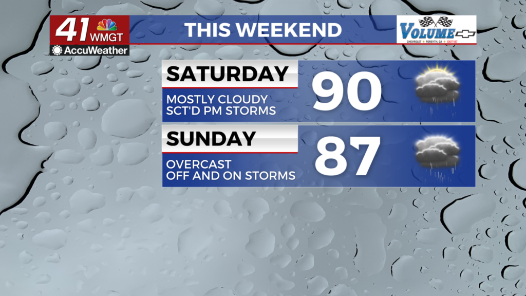
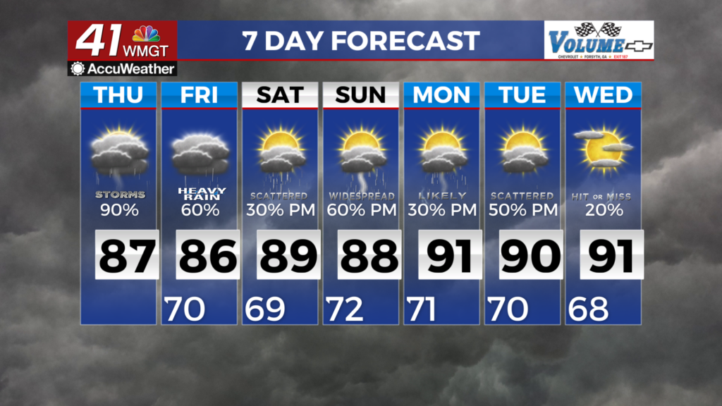
thunderstorms through the end of the week. Beginning the period, the remnants of what is now Tropical Storm Arthur are expecting to be moving out of the area by late Friday with improvements into the weekend. Some stray showers and thunderstorms will be possible late Friday into early Saturday morning as lingering tropical moisture moves east of the area. Low end rain chances will be possible each afternoon in the extended period, especially after this weekend once more humid air moves into the area. Temperatures are expected to return to average or slightly above average as high pressure centers itself just south of the state.