
Thunderstorm chances expected to increase by the weekend
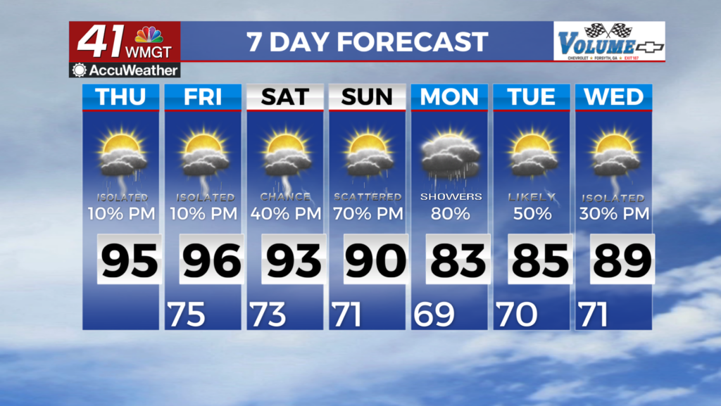
MACON, Georgia (41NBC/WMGT) – Another hot and dry day once again today despite the modest low level and deeper moisture in place. Similar to yesterday, temperatures will run in the mid 


90s in most locations. Changes begin to happen today as the mid level ridge anchored over Florida begins to weaken and shifts east as ridging develops over the western U.S. Additional moisture and less inhibition will become more available Thursday afternoon, therefore the possibility of precipitation begin to creep back up starting Thursday evening. Temperatures and dewpoints on Thursday will be similar to yesterday therefore the Heat Advisory for portions of Middle Georgia will be in place today and possibly again on Friday. Thunderstorm chances during the afternoon 


are expected to increase as we approach the weekend, especially across the northern part of the state. A slow moving front across the Southern Appalachians will eventually stall out over the southeast as the long term forecast picks up bringing unsettled weather along and north of I-20 this weekend. By Monday, the front will begin to move off increasing rain chances for the entire coverage area. The models indicate cooler and drier conditions are possible as we start next week, however the timing hasn’t been consistent between the runs. What that looks like will ultimately  come down to how quickly the weekend’s stationary front leaves the area. Widespread severe weather isn’t too much of a concern later this weekend. The Storm Prediction Center has us under a Marginal Risk on Saturday for far Northeast Georgia. The threat is mainly conditional afternoon convection and the primary threat will be the possibility for damaging winds. The approaching front and afternoon convection should bring us some relief from the heat. Highs in the low to mid 90s with feel-like temps in the triple digits will continue through Saturday before falling back into the 80s by the end of the weekend. The one saving grace is that as storms become more numerous in the afternoon, radiational cooling will help prevent a number of cities across the region from seeing peak heat during the afternoon and temps may not rise as high as they would without them.