The heat cranks up this weekend; storms possible Sunday
MACON, Georgia (41NBC/WMGT) – Temperatures will push 90 degrees this coming weekend with storms possible Sunday afternoon and evening.
This Evening


Conditions will remain clear around Middle Georgia heading into tonight as the wind finishes its shift from the northwest yesterday into the southeast tonight. Temperatures will likely valley in the lower 50s by Saturday morning.
Tomorrow


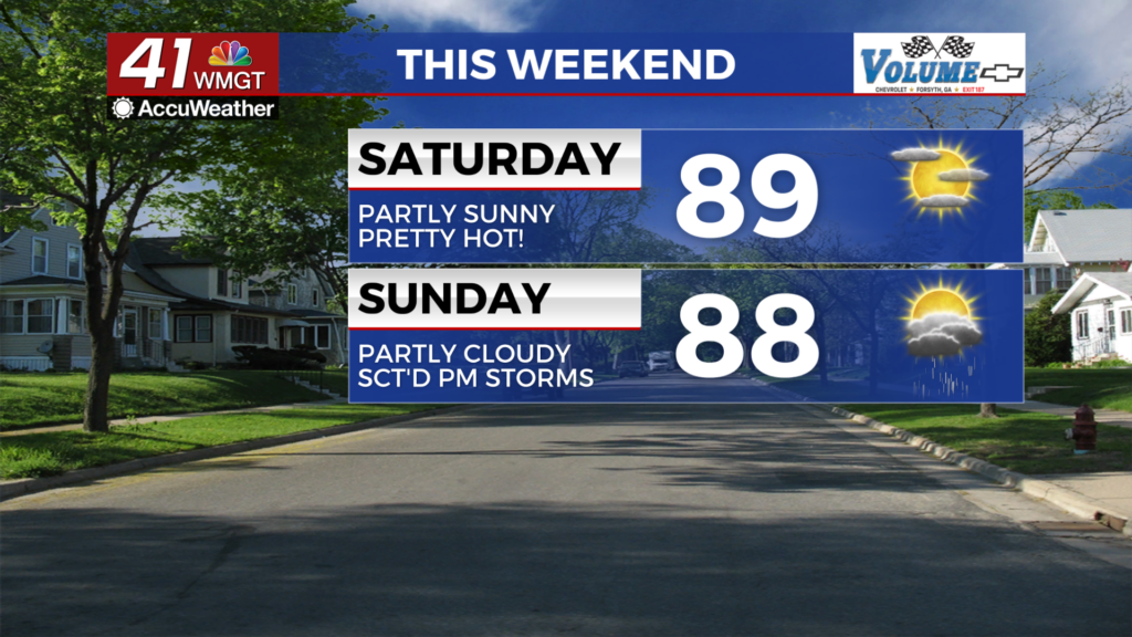
Temperatures will make a big jump Saturday afternoon with most spots likely to reach into the upper 80s. The hottest spots may graze 90. The wind will flow from the south-southeast around 5 mph. Skies should be relatively sunny however high clouds are expected overhead during the afternoon. Those spending ample time outdoors should wear sunblock as the UV index will be over 9.


Overnight will be partly cloudy with temperatures staying rather warm with lows expected in the low to mid 60s. There is a slim chance for a shower however rain is unlikely. The wind will remain light from the south-southeast.
Sunday and Beyond


Sunday will see partly cloudy skies with temperatures likely to top off in the upper 80s and lower 90s. Scattered storms are likely to begin during the mid afternoon, lasting through the evening. A bit more than half the region should see these storms and they ought to help out with some of the afternoon heat.

Temperatures will remain hot into the new week with rain chances dropping until late Wednesday afternoon.
Follow Chief Meteorologist Aaron Lowery on Facebook (Aaron Lowery 41NBC) and X (@ALowWX) for weather updates throughout the day. Also, you can watch his forecasts Monday through Friday on 41NBC News at 4, 5, 5:30, 6, and 11 p.m.