Sunny conditions are returning to Middle Georgia
MACON, Georgia (41NBC/WMGT) – A blocking pattern over the Eastern US will keep sunny weather over Georgia for the next several days.
Today


Conditions were cooler to begin the week in Middle Georgia. Most of the region saw early temperatures in the upper 40s and lower 50s. Skies were mostly clear to begin the day as well, however a few lower-level clouds have filled in since. These will clear as the lunchtime hours come on. Today will be the coolest day of the work week as highs top off in the mid to upper 70s around Middle Georgia. It is possible that one or two locations reaches 80 degrees. The wind will be rather consistent from the northeast at 5-10 mph. Gusts could reach up to 15 mph.


Skies will remain clear heading into tonight, allowing temperatures to cool rather quickly. The wind will shift slightly to the east, now coming in at 5-7 mph from the east-northeast. Overnight lows are likely to drop into the upper 40s and lower 50s around the region.
Tomorrow


Cloud cover will be at a minimum for the most part on Tuesday. Temperatures will rebound back into the lower 80s for most of the region with the warmest spots pushing towards the mid 80s. The wind will again come from the northeast, this time around 7-12 mph. Gusts could reach speeds upwards of 20 mph. Humidity will be rather low, so it will again feel rather pleasant outside.


Overnight the skies will remain clear as the wind shifts more towards the north, now coming from the north-northeast at 5-7 mph. Temperatures will still chill rather quickly, however they won’t get quite as cool, this time falling into the low to mid 50s. That is still below the average for the month of May in Macon, which is 60 degrees.
Wednesday and Beyond

Wednesday should see near cloudless skies as highs return to the mid 80s for most of the region. Winds will continue to come in from the northeast at 5-10 mph. Overnight lows will drop into the low to mid 50s once again.

Thursday we should begin to see some cloud cover come in from the east, though it may not happen until late. Highs during the afternoon will be in the mid 80s with northeast winds coming in at 10-15 mph. Overnight lows will warm into the lower 60s however, thanks to an increase in cloud cover.
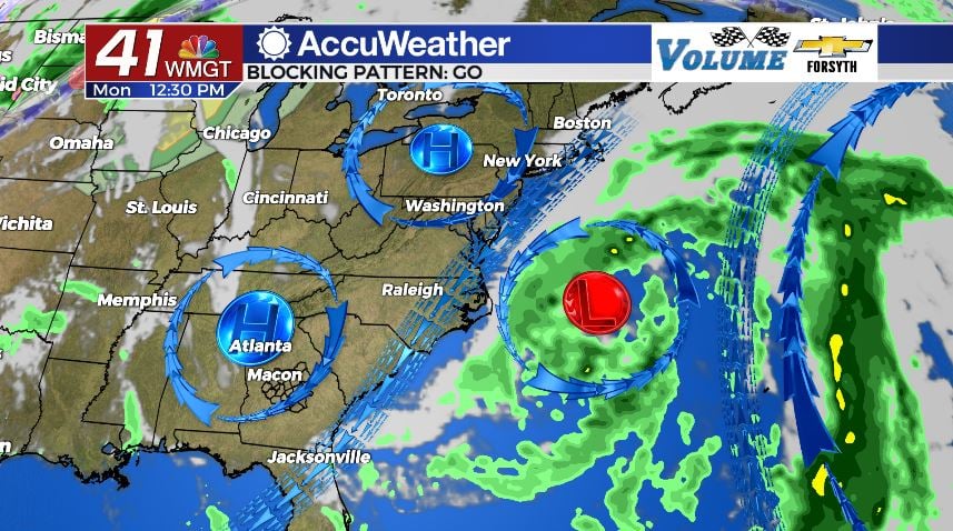
The storm system that passed through this past weekend has been caught in a bit of a blocking pattern thanks to it breaking off from the main jet stream. High pressure has set up over the Eastern US, and the Bermuda High is beginning to take form over the Atlantic. With this system stuck between, it is ultimately looping back around to impact the southeastern US from the east, which is atypical in the Mid-Latitudes of the Northern Hemisphere. Regardless, showers are anticipated for Friday afternoon around Middle Georgia. There shouldn’t be many other impacts outside of some gloomy clouds around the region with the system having weakened so much. Highs will reach the low to mid 80s with overnight lows dropping into the upper 50s and lower 60s. Highs should return to the upper 80s over the weekend, finally nearing the May average high of 86 in Macon.

Follow Meteorologist Aaron Lowery on Facebook (Aaron Lowery 41NBC) and Twitter (@ALowWX) for weather updates throughout the day. Also, you can watch his forecasts Monday through Friday on 41NBC News at Daybreak (6-7 a.m.) and 41Today (11 a.m).