Strong to severe storms possible overnight tonight and tomorrow
MACON, Georgia (41NBC/WMGT) – A slow moving incoming cold front will bring thunderstorms to Middle Georgia tonight and much of tomorrow with the possibility that a few may be severe.
This Evening


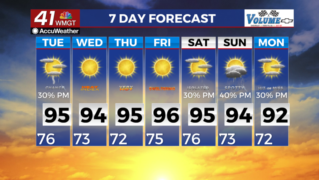
There’s been a lot of sunshine today and conditions have gotten rather warm with many locations reaching the upper 80s for high temperatures. It’s also been balmy too with several locations recording gusts from the southwest over 20 mph.


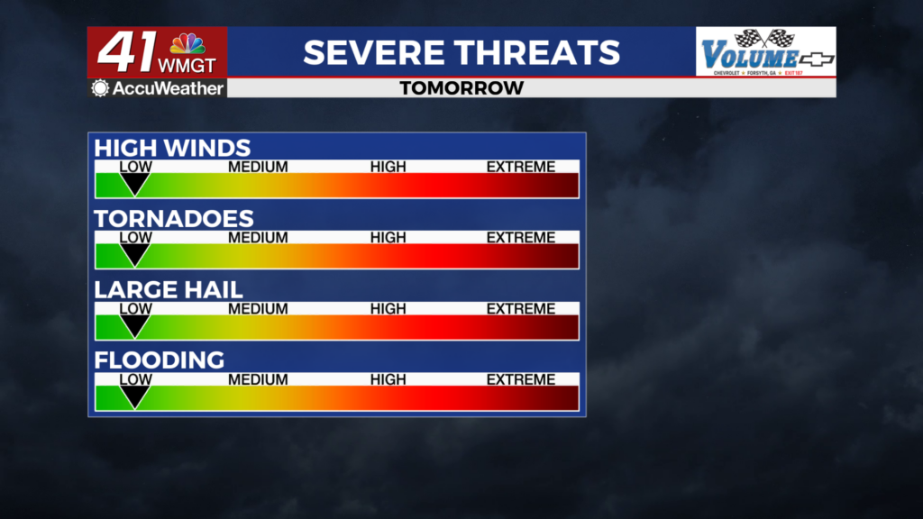
Cloud cover will increase this evening ahead of overnight storm odds. The northwestern counties of Middle Georgia are under a Level 2 “Slight” threat for severe storms until 8 AM tomorrow. Most of the rest of the region are under a Level 1 “Marginal” threat. The primary threat will be some damaging wind gusts or some hail, however the odds for a brief tornado are there. Tornado odds are slightly higher in the “Slight” threat zone. On top of severe threats the northwestern most counties of Middle Georgia are under a Flood Watch until 8 AM Thursday. Overnight temperatures will be rather warm with most of the night spent in the low to mid 70s. Low temperatures will largely be in the upper 60s. The wind will continue from the southwest at 5-15 mph with gusts pushing over 20 mph.
Tomorrow


Some rain will likely be ongoing as the sun comes up Thursday with the cold front likely to arrive in the region between 9 and 11 AM tomorrow. This will lead to another round of storms for most of Middle Georgia (the northwestern counties will likely be done with rain by then). As of now a Level 1 “Marginal” threat for severe storms includes most of Middle Georgia for tomorrow however an added Level 2 “Slight” risk for the southeastern half of the region cannot be ruled out at this time. This would likely rely on a bit of warming in those counties before storms arrive to provide a bit of extra energy.


Aside from storms Thursday will be overcast with temperatures likely to peak in the upper 70s and lower 80s in the afternoon (following the rain). The wind will shift from the southwest to the northwest throughout the afternoon at 5-15 mph. Gusts will likely continue over 20 mph.


Overnight will be mostly cloudy with a couple of showers possible early. Temperatures should drop a bit below average into the mid 50s for most of the region. The wind will flow from the north-northwest around 5-10 mph.
Friday and Beyond


Cloud cover will stick around to end the work week and head into the weekend, however rain odds should be down during the day on Friday. Those odds will likely increase some overnight before better odds for rain return once again on Saturday. Sunny skies may not return until late Monday afternoon of next week for much of Middle Georgia.

Follow Chief Meteorologist Aaron Lowery on Facebook (Aaron Lowery 41NBC) and X (@ALowWX) for weather updates throughout the day. Also, you can watch his forecasts Monday through Friday on 41NBC News at 4, 5, 5:30, 6, and 11 p.m.