Stormy Memorial Day Weekend on deck
MACON, Georgia (41NBC/WMGT) – Several rounds of thunderstorms are expected through this weekend and into next week around Middle Georgia.
This Evening
It’s been a partly to mostly cloudy and hot afternoon with plenty of humidity to fuel storms through the evening. Off and on activity is likely through suppertime and into the overnight hours. While organized severe weather is not expected the most intense storms may bring hail of up to an inch in diameter and downburst wind gusts of over 40 mph. Frequent cloud to ground lightning is also likely along with heavy rain.
Overnight some storms will linger likely past midnight before tapering off ahead of the sunrise Saturday. Widespread fog is likely following the rain this evening and tonight as the wind will flow from the southeast around 5 mph. Temperatures will valley in the upper 60s and possibly lower 70s.
Tomorrow
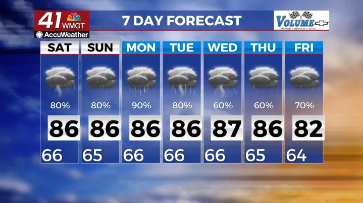
A mostly cloudy day is expected for the first half of the weekend with temperatures expected to climb into the mid to upper 80s. Storms should begin to fire up around lunchtime with several rounds likely through the late afternoon and evening. As mentioned above these storms may bring hail or some strong winds along with frequent lightning and heavy rain. Flash flood concerns will grow as the weekend progresses for areas hit with the heaviest rain repeatedly.
Overnight some storms will linger with a few sticking around after midnight. All activity should subside by the sunrise on Sunday. Fog will again be likely across the region following a wet Saturday evening. The wind will be light from the south-southeast with temperatures dropping into the upper 60s and lower 70s.
Sunday and Beyond
More sunshine is likely through the first half of the day on Sunday which should allow temperatures to warm into the upper 80s and lower 90s as the wind continues to flow out of the south around 5 mph. Storm odds will increase in the late afternoon and evening, again sticking around into the overnight hours.
More storms are likely Monday for Memorial Day with the bulk of the activity expected in the afternoon and evening. Those with barbecue plans this weekend or early next week should either cook early or find somewhere covered. It’s likely not going to be a good timeframe for swimming or being on the water with all the afternoon/evening storms as well. The wet pattern will continue through next week.
Follow Chief Meteorologist Aaron Lowery on Facebook (Aaron Lowery 41NBC) and X (@ALowWX) for weather updates throughout the day. Also, you can watch his forecasts Monday through Friday on 41NBC News at 4, 5, 5:30, 6, and 11 p.m.