Smoky conditions likely to continue Friday
MACON, Georgia (41NBC/WMGT) – Ongoing fires in South Georgia continue to grow and wind from the south will keep pushing smoke from them into Middle Georgia.
This Evening


It’s been another partly sunny and warm afternoon across Middle Georgia with conditions getting smokier the further south you go. Expect the reduced air quality to stick around through tonight with temperatures likely to drop into the low to mid 50s. A few spots could potentially drop into the upper 40s, however. Wind will be light and variable and overhead skies will largely be clear.
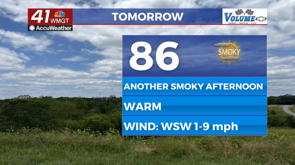
Tomorrow


Friday should be the warmest afternoon of the week with temperatures likely peaking in the mid to upper 80s. The smoky air will likely ensure nowhere reaches the 90s across the region. While a stray shower is possible more than likely it will just be a dry and partly cloudy afternoon. Wind will be light from the west-southwest at 5-10 mph.


Overnight a few more clouds may stick around as the haze sticks around. Temperatures should be warmer with most lows expected in the upper 50s and lower 60s around Middle Georgia. The wind will remain light from the southwest.
This Weekend and Beyond


Storm chances will finally climb this coming weekend as a cold front approaches from the northwest. While not everyone is guaranteed to see rain this weekend the majority of Middle Georgia should get some between the two days. At this time severe weather is overall not expected however a couple of well developed storms could bring a couple of damaging wind gusts or perhaps small hail. Storm chances will remain elevated into next week.

Follow Chief Meteorologist Aaron Lowery on Facebook (Aaron Lowery 41NBC) and X (@ALowWX) for weather updates throughout the day. Also, you can watch his forecasts Monday through Friday on 41NBC News at 4, 5, 5:30, 6, and 11 p.m.