Slight chance for showers and cooler temps start off new week
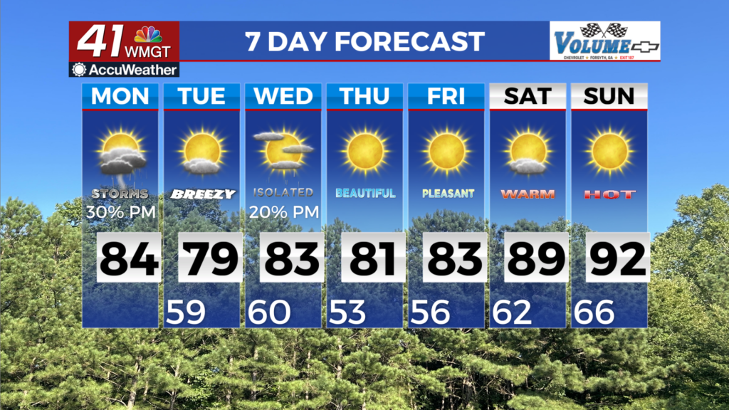
MACON, Georgia (41NBC/WMGT) – Models are continuing to trend toward weak forcing for the incoming cold front today. Precipitation chances have slipped to 20 percent for areas north of the 


metro and 30 percent for Middle Georgia. This will be enough moisture and energy to develop light scattered showers and a possible rumble of thunder or two. The chances for an isolated severe storm are low but not zero. Upper level flow from the northwest will continue in the coming days, keeping conditions cool. High pressure will drive northeast flow tonight which will drive weak wedging and may bring low clouds tonight. Surface high pressure sliding off to the east will turn winds out of the south on Wednesday, increasing low level moisture over the area. At the same time, a shortwave and an associated cold front will be dropping across the Great Lakes and much of the Eastern U.S. by late in the day. The combination of forcing from the front and low level 


moisture may support a few showers or storms in our area during the afternoon and evening. Following this, a reinforcement of dry northwest flow spreads over the region, keeping conditions rain-free through the rest of the week. Temperatures will vary from day to day Wednesday through Friday, but remain around normal for this time of the year, with highs in the 70s to low 80s. Overnight lows in the 50s. Over the weekend, temperatures will rapidly warm up as a ridge builds from the Gulf up across the Southeast U.S. Highs soar into the upper 80s to low 90s, with overnight lows in the 60s. Between subsidence from the ridge and a relatively dry airmass in place, rain chances will remain near zero.