Hot temperatures engulfs Middle Georgia
MACON, Georgia (41NBC/WMGT) A high pressure center persists across the eastern U.S., with a midlevel anticyclone centered over the Appalachians. Hot conditions will continue underneath 


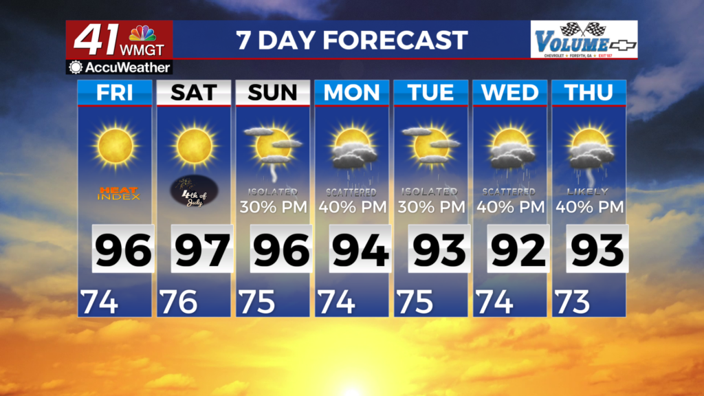
this pattern. Low temperatures started the morning in the mid to upper 70s across North Georgia, which has done very little in providing relief from the ongoing heat. With slightly drier air working its way into Middle Georgia, lows will be closer to normal in the morning. High temperatures reached into the mid to upper 90s. In portions of Middle Georgia, dewpoints in the upper 60s to near 70 will prevent heat indices from reaching Heat Advisory criteria. Higher dewpoints in the mid 70s in the northern half of the forecast area will allow dewpoints to climb into the mid to 

upper 100s, warranting a Heat Advisory for our northern counties. Strong diurnal destabilization is expected across North Georgia once again today, where temperatures and dewpoints are highest. This instability, could lead to a microburst threat which could lead to damaging wind gusts. Scattered convection and storm clusters could develop in the far northeast portion of the state. Thunderstorms will continue to fire off through the early evening. Because of this, there is a Slight Risk (Level 2 of 5) for severe weather in place for a large area along and north of Atlanta, with a Marginal Risk (Level 1 of 5) to the immediate south. Damaging wind gusts will be the primary threat with any strong to severe thunderstorms that occur. Large hail will be a secondary threat with the strongest storms. Storms will also produce frequent lightning and locally heavy rainfall. Upper level ridging centered over the Mid-Atlantic region moves offshore this weekend with a more disorganized pattern taking hold Sunday and into next week.