
Rain returns to Middle Georgia Thursday
MACON, Georgia (41NBC/WMGT) – A weak cold front will bring some showers to Middle Georgia Thursday afternoon before heavier rain moves in overnight.
Today
Mostly cloudy skies will be with Middle Georgia throughout the day today. Temperatures will peak in the 70s this afternoon with south-southwest winds blowing in at 5-15 mph. Gusts could push as high as 30 mph. Showers will also be possible throughout the day with a rumble of thunder or two possible in the evening. The northwestern counties will have higher odds to see the showers, however heading into the later evening hours some heavier rain will move into the region. That could impact anywhere in Middle Georgia.


The heavy rain in the evening is expected to at least slow after midnight with some models hinting that it may stop. Some models see rain moving back in ahead of the sunrise tomorrow; some don’t see it returning until lunchtime on Friday. Middle Georgians should have their rain gear ready as if there will be rain out the door tomorrow. Low temperatures will be in the mid to upper 50s.
Tomorrow
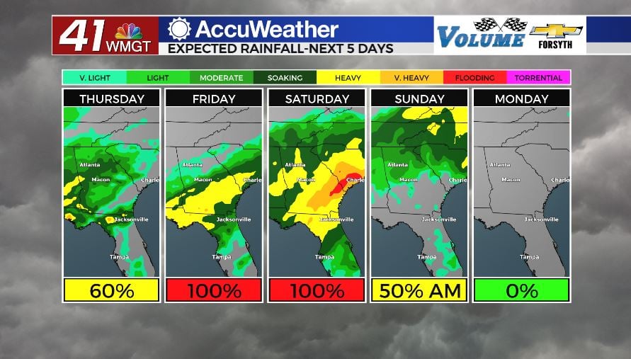
Friday will be a wet day for Middle Georgia. Whether that rain begins at 7 am or noon, the rest of the day will be spent dealing with it. Middle Georgians should anticipate it to likely move in during the later morning hours ahead of lunchtime. While it will largely be stratiform rain, some thunderstorms will be possible during the afternoon and evening, particularly in the southeastern counties.


At this time the SPC has issued a Level 1 “Marginal” threat for severe weather for Friday afternoon that includes a few southeastern Middle Georgia counties. More than likely the pattern will be too cool and wet for anything severe to get going in the region, but the SPC will not rule out an isolated strong wind gust or super brief spin-up tornado. High temperatures will occur overnight Thursday into Friday as well, further limiting heat during the window for storms. Flash flooding will be a concern for most of the region, however, especially as the weekend progresses.


Rain will continue all night Friday and into Saturday morning. Middle Georgians should expect flooding in low lying areas as the stratiform rain persists. Winds will blow variably from the north at about 2-10 mph with gusts reaching as high as 17 mph. Temperatures will bottom out in the upper 40s and lower 50s.
Saturday: The Washout
Middle Georgians should stay in on Saturday unless they absolutely must go somewhere. Moderate to heavy rain is expected all day long, and winds will be rather strong during the afternoon. Sustained speeds will range from 10-20 mph with gusts pushing upwards of 40 mph. This will make visibility extremely low on the roadways, and on top of that flooding will be likely in many areas following all of the persistent rain from Friday and Friday night. Some spots in Middle Georgia could see rain totals pushing 4 inches by the end of Saturday (rolling totals beginning Thursday with the arrival of the cold front). Rain is expected to persist into Sunday morning but should clear out ahead of the evening (at the latest). Middle Georgia should get a day of sunshine on Monday.

Follow Meteorologist Aaron Lowery on Facebook (Aaron Lowery 41NBC) and Twitter (@ALowWX) for weather updates throughout the day. Also, you can watch his forecasts Monday through Friday on 41NBC News at Daybreak (5-7 a.m.) and 41Today (11 a.m).