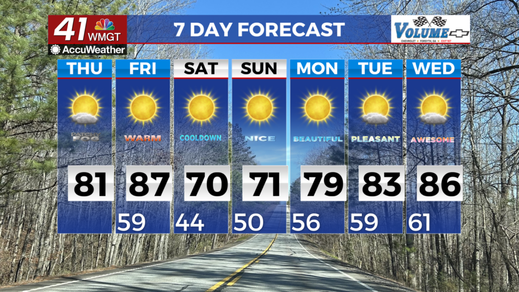
Pleasant weather hangs around to begin the new week
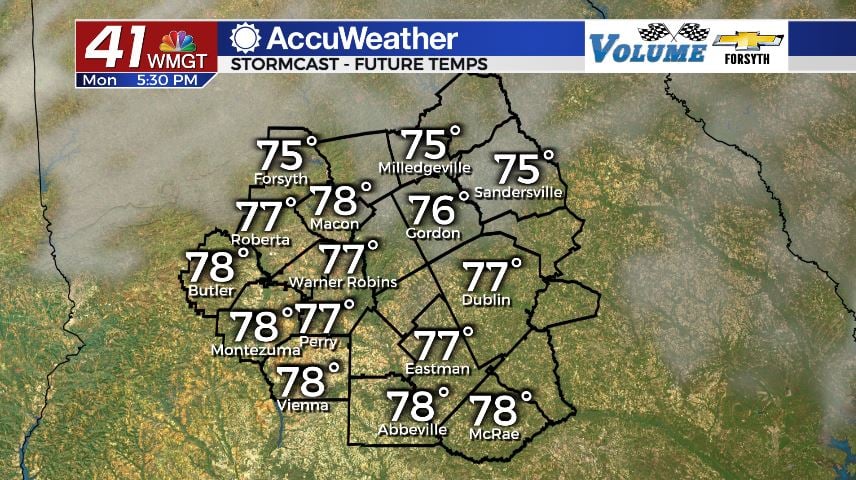
MACON, Georgia (41NBC/WMGT) – Warm and sunny conditions are carrying over from the weekend in Middle Georgia today.
Today


It was a chilly morning to kick things off in Middle Georgia. Temperatures for most of the region were below 45 degrees at the time of the sunrise. The chills will not last, however. Highs this afternoon around Middle Georgia are in the upper 70s and lower 80s. Cloud cover will be a bit more prominent than yesterday, but there shouldn’t be as many as Saturday. This afternoon’s clouds will primarily be high level cirrus clouds. These are often seen when a large storm system is expected to move in the next day (hint hint). As for wind this afternoon, it will hover around 5 mph as it gradually shifts from the southeast towards the southwest.


Tonight we will see more cloud cover fill in at the mid-levels, however it likely won’t really increase until closer to tomorrow morning. The winds will shift back towards the south-southeast, blowing in at 5-10 mph. Forecast low temperatures are in the mid to upper 50s by tomorrow morning, largely being kept warm by those southerly winds and insulation of cloud cover.
Tomorrow


When you leave home tomorrow, do not forget your umbrella/raincoat or rain boots. Plenty of rain is expected around the Peach State tomorrow, and Middle Georgia is no exception. It will begin to move into the region ahead of lunchtime and stick around the area most of the afternoon. Scattered storm activity is likely to follow the heavy rain in some of the southern counties. The majority of the rain, however, is anticipated to fall in the northern counties.


First off, there is a Level 3 “Enhanced” risk for severe weather tomorrow. It includes all of Middle Georgia. With the washout conditions moving in, however, the threat of tornadoes or hail is extremely low. Strong straight line winds are definitely a concern, however the number one threat is Flash Flooding, primarily in the northern counties of the region. Forecast rain totals in places like Macon and Forsyth are more than 3 inches. That’s just for tomorrow afternoon. The southern counties, by contrast, are expected to keep it under an inch. Those places could see scattered storm activity later in the evening, and that is when a potential tornado threat could show itself. The more rain that is received ahead of the isolated evening storms, the lower the overall severe threat will be.


Overnight cloud cover will remain abundant and scattered showers will likely persist. It will stay very warm overnight as winds blow in from the southwest at 5-15 mph. Gusts could reach upwards of 25 mph. Low temperatures rolling into Wednesday morning are forecast to be in the low to mid 60s.
Wednesday and Beyond


Wednesday brings another severe weather threat to Middle Georgia, currently set as a Level 2 “Slight” risk for most of the region, however Monroe County is currently under the Level 3 “Enhanced” risk. The setup unfortunately looks more conventional to a typical “severe weather” day, so expect afternoon storms that could actually pose a bit of a tornado threat. Highs in the region are expected to be in the low to mid 80s that day: plenty of fuel for storms. If cloud cover can remain more blanket-like through the lunchtime hours, it could keep the overall severe threat down by keeping the highs down a couple of degrees. A line of weaker storms (with the cold front) will potentially move through behind the isolated storms once the sun sets.

A bit of rain may be left early Thursday morning, but expect the sunshine to return by the middle of the day. Highs will be in the mid to upper 70s with lows in the mid 40s.
Friday will see a good amount of sun, but scattered clouds are likely do develop in the afternoon. It looks like there could be some strong breezes throughout the day as well. Highs will be in the mid 60s, lows in the upper 30s and lower 40s. The cold snap should fully take hold by Saturday.

Follow Meteorologist Aaron Lowery on Facebook (Aaron Lowery 41NBC) and Twitter (@ALowWX) for weather updates throughout the day. Also, you can watch his forecasts Monday through Friday on 41NBC News at Daybreak (6-7 a.m.) and 41Today (11 a.m).