Off and on storms possible through tonight
MACON, Georgia (41NBC/WMGT) – A slow advancing cold front will continue to bring showers and storms to Middle Georgia through tonight and into tomorrow.
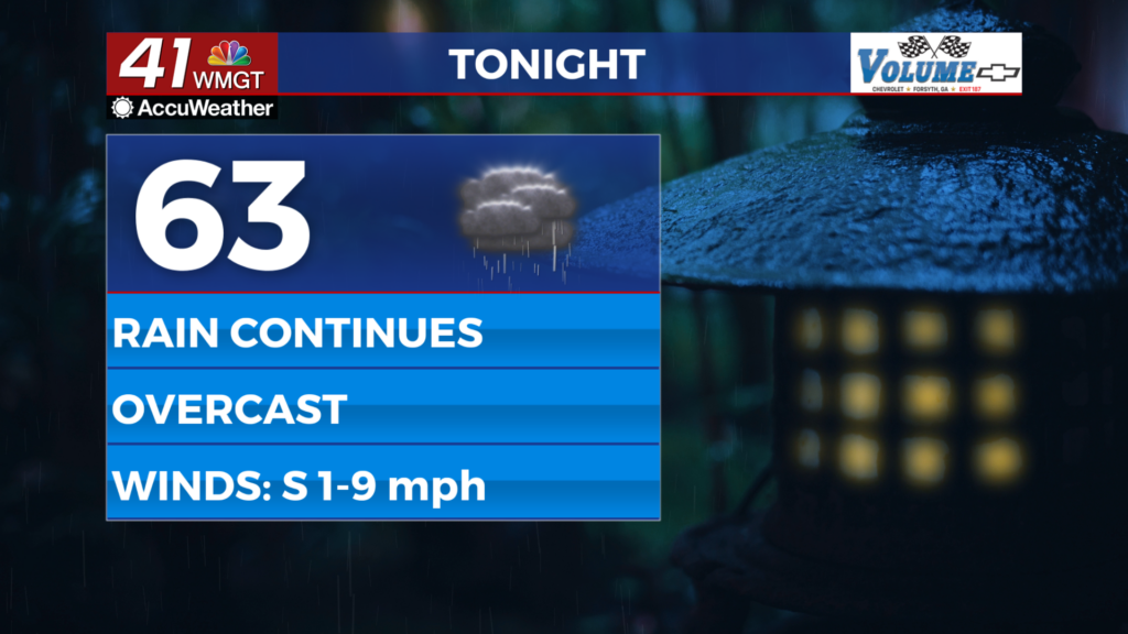
This Evening and Overnight


Skies across Middle Georgia will remain overcast through this evening and tonight as rain chances remain elevated. Overall activity should be isolated in nature until overnight when another widespread wave of storms is expected. Severe weather is not anticipated however the strongest storms may bring a couple of damaging wind gusts or small hail. Tornadoes are not a concern with storms tonight. Expect rain to be ongoing during the sunrise tomorrow.


Aside from the rain the wind will be light generally out of the south. Expect temperatures to remain quite warm with lows likely to be over 60 degrees across the region.
Tomorrow


Rain will continue through the sunrise before tapering off by lunchtime tomorrow. Temperatures should be a good bit warmer as highs are likely in the low to mid 80s, especially if sunshine can return a bit earlier than expected. The wind will be rather breezy from the west at 5-15 mph. Gusts will likely push 20-25 mph throughout the afternoon.


Overnight cloud cover will fill back in and more showers and storms are likely leading into the early parts of Thursday. While severe weather is not anticipated the southwestern counties are currently under a Level 1″Marginal” threat from 8am Wednesday to 8am Thursday. The hazards are a couple of damaging wind gusts or some hail. Temperatures will valley in the lower 60s and upper 50s for the coolest spots. The wind will be light from the northwest.
Thursday and Beyond


Thursday will be borderline overcast with isolated showers and storms likely during the day. High temperatures will be cooler than Wednesday with most spots likely to reach the mid to upper 70s. The wind will continue from the northwest around 5 mph. Rain odds will increase again come Friday with Saturday looking like a washout across the region. Sunnier conditions will return on Sunday.

Follow Chief Meteorologist Aaron Lowery on Facebook (Aaron Lowery 41NBC) and X (@ALowWX) for weather updates throughout the day. Also, you can watch his forecasts Monday through Friday on 41NBC News at 4, 5, 5:30, 6, and 11 p.m.

