Fire threats remain elevated Thursday
MACON, Georgia (41NBC/WMGT) – Conditions will remain hazy outside thanks to ongoing fires in South Georgia and the danger for new fires remains heightened.
This Evening


Smoky haze moved into Middle Georgia overnight last night with a gust front that progressed northwest from the southeast with a shift in wind direction. The wind will continue to flow generally from the south with another one of those gust fronts possible tonight. South Georgia is currently seeing some pretty large wildfires that may continue to grow (along with the possibility for new fires thanks to exceptional drought conditions). The levels of smoke may increase further tonight as a result. The smoke keeps conditions warmer than expected so lows should largely hover in the mid 50s. Skies overhead will be clear.
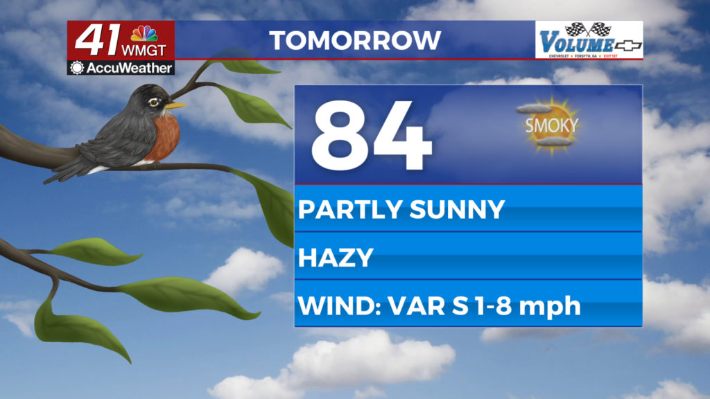
Tomorrow


While plenty of sunshine is likely early it may be damped by smoky haze in the area. Expect the air quality to at least remain as bad (over 100) if not worsen throughout the day tomorrow. Another Fire Danger Statement is likely for much of Georgia as well. Temperatures will peak in the mid 80s under partly sunny skies. There is a slim chance for a rain shower or two, but impacts of any potential rain will be negligible. The wind will remain light generally from the south.


Overnight will be mostly clear and hazy as the wind continues with the southerly flow. Temperatures should valley in the upper 50s for most of the region.
Friday and Beyond


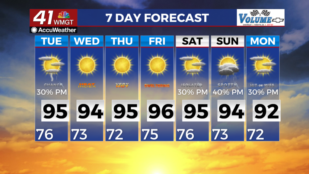
Friday will continue the current pattern and should see the warmest conditions of the week. A couple of isolated showers or perhaps a storm will be possible in the afternoon/evening. Meanwhile Saturday will see a great increase in storm odds as most if not all of Middle Georgia should be impacted. The odds for severe weather are low at this point but cannot completely be ruled out. Look for the Storm Prediction Center (SPC) to include parts of the region in a Level 1 “Marginal” threat. Rain chances will remain elevated compared to recent weeks through the weekend and into next week.

Follow Chief Meteorologist Aaron Lowery on Facebook (Aaron Lowery 41NBC) and X (@ALowWX) for weather updates throughout the day. Also, you can watch his forecasts Monday through Friday on 41NBC News at 4, 5, 5:30, 6, and 11 p.m.