Chances for showers decrease as heat increases
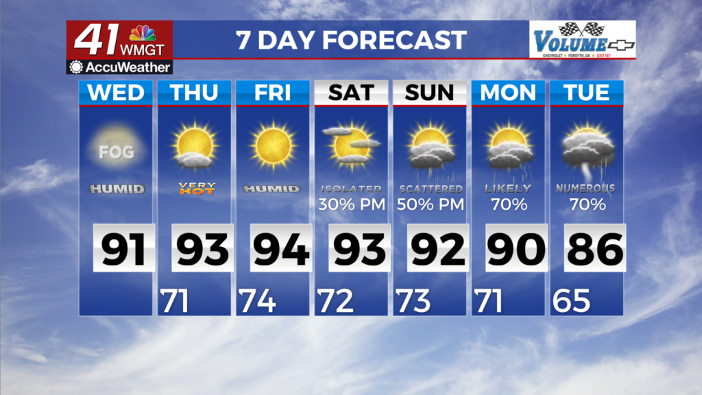
MACON, Georgia (41NBC/WMGT) – Wednesday brings lower rain chances as upper ridging extends its grip eastward across the southern U.S. The odds for more organized convection associated 


with any weak lingering shortwave look likely to remain north and east of the area today, however isolated diurnally driven showers can be expected. Outside of any showers and storms, warm and muggy conditions can be expected as dewpoints remain in the upper 60s to mid 70s. Actual high temperatures nudge back into the upper 80s to low 90s Wednesday afternoon. This will result in heat index values in the mid to upper 90s for most areas outside of the mountains. At the start of Thursday, presiding high pressure at the surface and weak flow aloft will support 


mainly diurnally-driven, summerlike chances for afternoon thunderstorms throughout the remainder of the week and into the beginning of the weekend. Southeasterly to southwesterly flow around the western edge of the Bermuda High continues to funnel a moisture airmass across the Southeast. As a result, any showers and thunderstorms that form will be efficient rainfall producers, and localized or nuisance flash flooding concerns are likely. Heat will continue to build under lingering ridging, with highs warming a degree or two each day through Saturday, when highs will be in the 90s for most. Throughout the day Saturday, a cold front approaching from the northwest will breach the area and linger around its midsection. Associated frontal lift will help bolster chances for showers and thunderstorms through the remainder of the weekend and into next week (chances 50% or greater). Some weak organization of storms is possible largely from outflow boundary influences. Increased cloud cover and the influence of the front will temper highs Sunday and Monday, noticeably cooler in the 80s to lower 90s.