


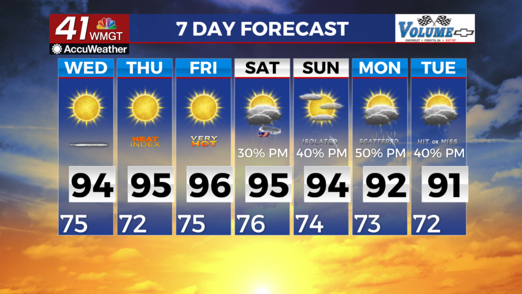
Another Heat Advisory Day on tap for Wednesday
MACON, Georgia (41NBC/WMGT) – High pressure remains the dominant feature across the area, keeping temperatures high through Georgia. The main concern continues to be hot temperatures 


and triple digit heat indices. Given the amount of moisture today, expect heat indices of 106 to 110, mainly for the western and into Middle Georgia locations. For this, a Heat Advisory for the majority of the area will be in effect through 8 PM. As for Wednesday, winds continue from the northeast. These northeast winds will help to pull in slightly drier air into the region and lower the dewpoints a tad bit. These small dips in the dewpoints have a more noticeable change for heat indices. Wednesday is expected to have less widespread heat advisories, however counties in NW Georgia have higher chances for heat indices reaching 105-109. Most likely another Heat Advisory will be in effect for Wednesday from 12 PM to 8 PM for a portion of Northwest Georgia. As for 


shower and thunderstorm activity for the rest of the day, the northeast winds do pull in a slightly drier air towards Middle Georgia leaving a better chance in western locations. Given the environment, a few storms into the evening hours could become a bit strong with the main hazard being from microbursts. The primary location for these storms will be western into central portions of Georgia with about a 30 percent chance. For Wednesday, coverage of showers migrates north with a slight chance (30-40 percent) for a typical to strong thunderstorm. The key messages of impactful heat and daily thunderstorm chances continue through the extended period. The ridge is still set to shift southward towards the weekend, but the exact placement of the high 

pressure center is still uncertain. The most recent models suggest the ridge may setup further east over the Atlantic instead of over the southeast U.S. This may have some influence on temperatures in the coming days, but the overall message of heat prevails. Therefore, a noticeable uptick in the chances for precipitation remains valid during the afternoon and evening timeframes. Heat index values look to decrease slightly at the forefront of the long term period, but could rise again this Fourth of July weekend as the upper ridge is suppressed to the south. Impactful temperatures are expected with heat indices ranging from the upper 90s to lower 100s, and in some isolated areas could exceed 105 degrees for the next several days! This will exasperate heat risk, Thursday through Saturday.