


Hot weather continues to begin the new week
MACON, Georgia (41NBC/WMGT) – Middle Georgia will see above average temperatures Monday afternoon.
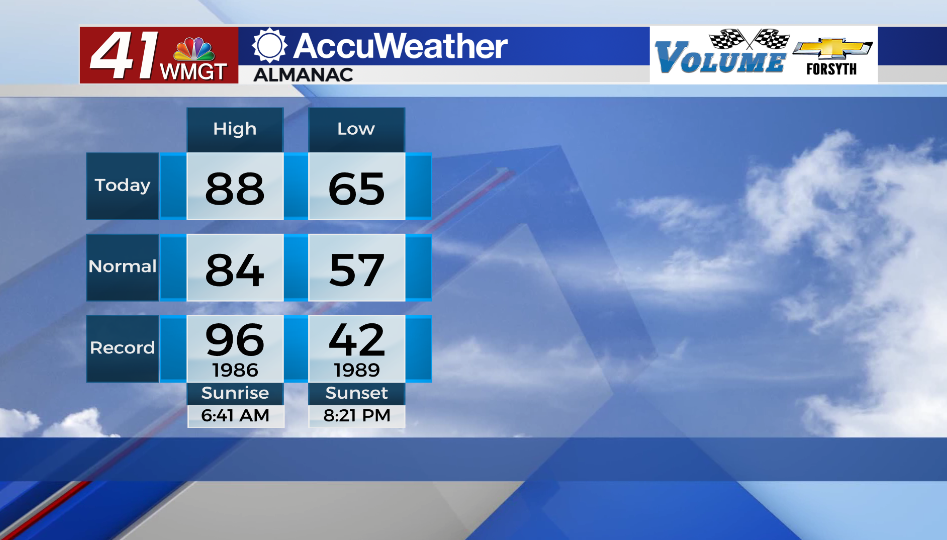
Today
Partly cloudy skies will hang with Middle Georgia throughout the daylight hours today. Temperatures will climb into the mid to upper 80s around the region. The wind will blow out of the west-southwest at about 5-12 mph throughout the afternoon. A couple of isolated showers and storms will be possible through the late afternoon and evening hours. They should be short lived, however some could have moderate to heavy rain. The UV indexes around the region will range from 8.5 to 9 this afternoon.


Tonight partly cloudy skies will stick around along with warm and muggy conditions. Winds will continue to blow from the west-southwest/west at about 5-10 mph with low temperatures in the mid to upper 60s. A stray shower or two will be possible overnight as well.
Tomorrow
Tuesday will likely be more of the same with hotter afternoon temperatures. Highs will largely reach into the upper 80s and lower 90s across Middle Georgia. Winds will largely blow out of the west/west-northwest at about 10-15 mph, helping to take the edge off the hot afternoon. A few isolated to scattered storms will be possible over the back half of the day.


Tomorrow night should be mostly clear, however a shower or two will still be possible. Winds will blow out of the northwest at about 5-10 mph with low temperatures again in the mid to upper 60s.
Wednesday and Beyond
Wednesday should see mostly sunny skies before partly cloudy conditions return both Thursday and Friday. Wednesday and Thursday should also largely see highs in the upper 80s before the 90s return Friday and over the weekend.

Follow Meteorologist Aaron Lowery on Facebook (Aaron Lowery 41NBC) and Twitter (@ALowWX) for weather updates throughout the day. Also, you can watch his forecasts Monday through Friday on 41NBC News at Daybreak (5-7 a.m.) and 41Today (11 a.m).


