Fire danger high Tuesday afternoon
MACON, Georgia (41NBC/WMGT) – Blustery winds and low humidity will keep fire threats high across Middle Georgia Tuesday.
Today


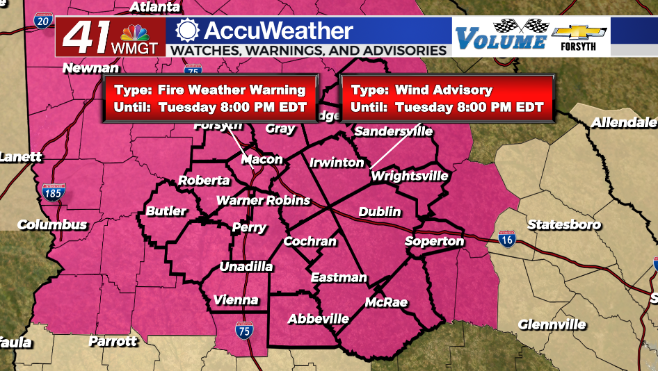
Sunny skies will stick with Middle Georgia all day today as temperatures climb into the mid to upper 70s. Relative humidity through the afternoon will likely range from 25-30% around the region. Winds around Middle Georgia today will range from 15-25 mph with gusts reach as high as 35 mph. This has prompted the NWS to issue a Wind Advisory until 8:00 PM EDT tonight. A Red Flag (Fire Weather) Warning is in effect until 8:00 PM EDT tonight as well. UV index values around the region will hover around the 9 mark this afternoon, so anyone enjoying the below average temperatures needs to wear protection.


Tonight a couple of clouds may pass through early, otherwise skies should stay clear. The winds will back off a bit as they shift more to the west-northwest, however gusts could still push 15-20 mph heading into tomorrow morning. Temperatures should bottom out in the upper 40s with wind chills in the mid 40s to begin Wednesday morning.
Tomorrow


Blustery conditions will continue to stick with Middle Georgia Wednesday afternoon, however this time the wind will largely blow out of the northwest. Gusts will still push 30 mph with sustained speeds ranging from about 10-20 mph. Thanks to the direction shift high temperatures will likely be a couple of degrees cooler than Tuesday afternoon. Fire dangers will remain high while the strong winds are prevalent.


Tomorrow night will be the coldest night of the week with low temperatures dipping into the low to mid 40s. Wind chills will largely be in the lower 40s out the door Thursday morning. Overhead skies should remain mostly clear.
Thursday and Beyond

Calmer winds will return to the region Thursday afternoon along with a little bit of cloud cover. Winds will shift to the south ahead of Friday allowing moisture return to commence and additional cloud cover to fill in. Rain chances will start to ramp up heading into the weekend thanks to the moisture increase, however due to to a ridging pattern building into the jet stream to finish the week those storm chances will be scattered and not driven by a low pressure system. Mostly cloudy conditions are likely over the weekend, especially on Sunday.

Follow Meteorologist Aaron Lowery on Facebook (Aaron Lowery 41NBC) and Twitter (@ALowWX) for weather updates throughout the day. Also, you can watch his forecasts Monday through Friday on 41NBC News at Daybreak (5-7 a.m.) and 41Today (11 a.m).


