Wet Monday to begin the first week of April
MACON, Georgia (41NBC/WMGT) – A small weather low pressure system will bring soppy weather to Middle Georgia for much of the day Monday.
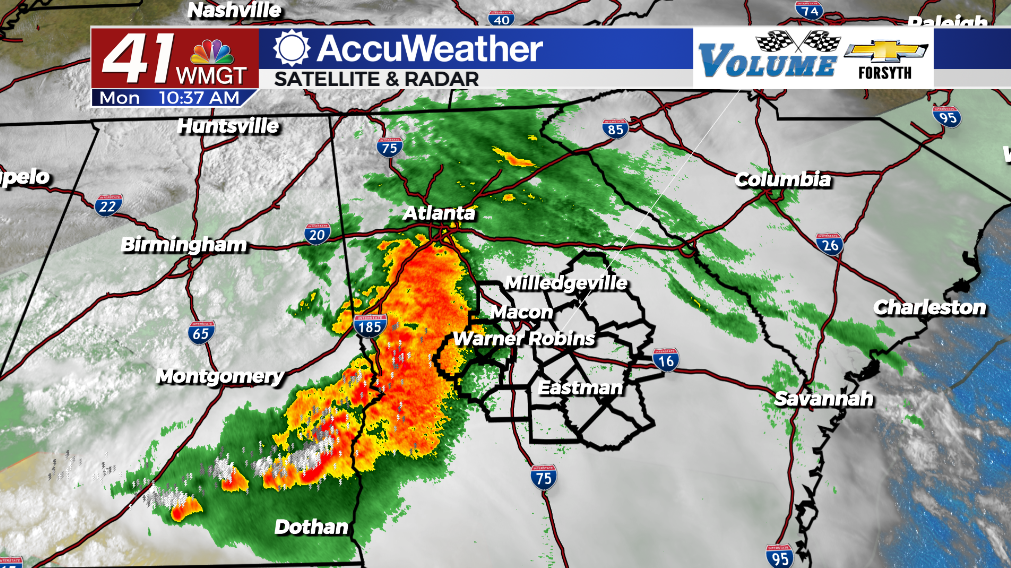
Today


Middle Georgia is in for a messy afternoon as widespread moderate to heavy rain pushes into the region from the west. Now not all of Middle Georgia will see heavy rain today as the system should weaken as the day progresses. Those to the west of I-75 will most certainly see a good deal of rain. Those just to the east should also see a decent amount, however the western third of the region may only get a couple of storms/showers. As a result, high temperatures are in the upper 60s for much of the western half of the region but the low to mid 70s for the east. Rain should taper off as the evening draws on around the region. There shouldn’t be much ambient wind today (SE 3-12 mph), however some storms could have a few strong gusts (mainly southwestern counties).


Clouds will clear out initially heading into tonight, however a few showers will remain possible and cloud cover will return ahead of Tuesday morning. Low temperatures will be in the upper 50s and lower 60s with variable winds at 1-10 mph. Fog will be likely around much of the region to begin our Tuesday thanks to lingering moisture from the day’s rainfall.
Tomorrow


It will be a cloudy start around Middle Georgia before things clear later in the afternoon. A couple of small showers will be possible early, however much of the region should stay dry. During the afternoon temperatures will peak in the mid 80s around the region as winds blow in from the south-southwest at about 2-10 mph. Some scattered cloud cover may remain, but the sun will dominate the back half of the day.


Tomorrow night expect mostly clear conditions as temperatures cool into the low to mid 60s. Some patchy fog will be possible heading into Wednesday morning.
Wednesday and Beyond


Wednesday will be very hot (and partly sunny) around Middle Georgia with the potential to set some new record highs. Upper 80s are where most of the region should top out, however some low 90s cannot be ruled out. A couple of spotty storms will be possible in the afternoon. Thursday will also be hot as well, however a bit of added cloud cover should keep temperatures slightly cooler than Wednesday afternoon. There will also be the possibility for a couple of pop-up storms. A cold front will arrive on Friday, bringing rain and cooler conditions. This front is expected to stall out and thus more rain is expected both days Easter Weekend.

Follow Meteorologist Aaron Lowery on Facebook (Aaron Lowery 41NBC) and Twitter (@ALowWX) for weather updates throughout the day. Also, you can watch his forecasts Monday through Friday on 41NBC News at Daybreak (5-7 a.m.) and 41Today (11 a.m).


