Icy Roads Still A Threat in Middle Georgia Thursday Morning, Warm Weather Ahead
MACON, Georgia (41NBC/WMGT) – Wednesday’s winter storm brought over two inches of snow to some parts of Middle Georgia. Most of the snow melted in the afternoon as temperatures rose slightly above freezing. However, clear skies lead to maximum cooling in the evening and overnight hours, resulting in sub-freezing temperatures Thursday morning.
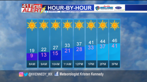
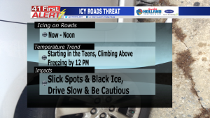
Throughout the morning Thursday, temperatures are expected to stay below freezing. It will feel even colder (teens & single digits) with a wind from the northwest at 5-10 mph. It’s not until noon that enough warming will occur to cause temperatures to get above 32 degrees.
Because the arctic air is sticking around through the morning, there is still a threat of ice on the roadways. Any snow or ice that melted Wednesday likely refroze at night when temperatures dropped below 32 degrees. Drive slowly and be cautious of slick spots or patches of ice leftover on the roads this morning.
Any remaining snow or ice will melt completely Thursday afternoon with high temperatures in the middle and upper 40’s.
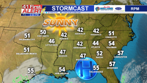
A ridge of high pressure will set up over the southeast for the next few days. This system will cause air to sink and compress, resulting in dry air and minimal cloud cover. Temperatures will also start to climb upwards as the air heats up.
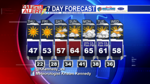
Warmer weather is on the way! Middle Georgia will have experienced two seasons of weather by the weekend. We definitely got a dose of winter on Wednesday, but by Sunday it’ll feel more like Spring with temperatures in the 60’s. Rain chances return Monday with another front moving into the state.
Connect with Meteorologist Kristen Kennedy on Facebook and Twitter for weather updates throughout the day. You can also watch her forecasts on 41NBC News at Daybreak (5-7 a.m.) and 41Today (11 a.m.) Monday-Friday.


Leave a Reply