
End of the rain train in sight for Middle Georgia
MACON, Georgia (41NBC/WMGT) – Tuesday will bring the last chance for rain to Middle Georgia until Saturday.
Today
For some folks in Middle Georgia, it is over. The storm after storm after storm training over the same areas, brining relentless flows of water. Reservoirs overflowing, dams breaching, rivers flooding, roads closing, etc have all been issues for the northern counties in Middle Georgia. Milledgeville and Baldwin County even saw a brief tornado Sunday morning. For those counties, they will be lucky (not actually) if they see a shower today. Mostly cloudy conditions along with winds slowly increasing out of the north should be expected for the northern third of the region. Highs will reach into the lower 70s in these spots.
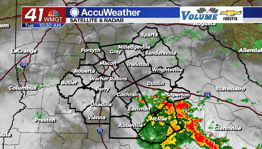
The southern half of the region will see another round of storms that will likely persist much of the day. Temperatures will only climb into the upper 60s as a result. Keep in mind that Sunday evening and Monday afternoon these spots saw some scattered storms with heavy rain, however it wasn’t quite the same that the northernmost counties got. Flash flood warnings were not issued, and for this afternoon the only real severe weather threat is a couple of wind gusts. Low lying areas could see some flash flooding along with any spot that sees training of storms of heavy rain. Rain should clear out of the area before the overnight hours.


Tonight all of Middle Georgia will be on the same wavelength as cloud cover breaks up a good bit. Temperatures will drop into the mid to upper 40s with north-northwest winds at 5-15 mph. Gusts could reach as high as 25 mph.
Tomorrow
The rain will be done with all of Middle Georgia tomorrow, however cloud cover will not. Fortunately, the clouds will largely be upper level cirrus clouds that let through a bit of sun, especially further north. The southern counties could still have some thick cloud cover early. It will be the coolest afternoon of the week with highs in the mid to upper 60s. Winds will blow from the northeast at about 5-15 mph. Gusts could reach as high as 20-25 mph.


Cloud cover will clear out ahead of the overnight hours bringing clear skies to Middle Georgia for the first time since Friday afternoon. Temperatures will bottom out in the low to mid 40s with light and variable winds.
Thursday and Beyond
Thursday will be a lovely day across Middle Georgia with sunny skies and highs back into the mid to upper 70s. Winds will blow from the east-southeast at about 5 mph as high pressure passes north of the region. We will continue to see mostly sunny conditions through Friday with a cold front likely to bring more storms Saturday.

Follow Meteorologist Aaron Lowery on Facebook (Aaron Lowery 41NBC) and Twitter (@ALowWX) for weather updates throughout the day. Also, you can watch his forecasts Monday through Friday on 41NBC News at Daybreak (5-7 a.m.) and 41Today (11 a.m).