Storm chances to increase for the remainder of the week
MACON, Georgia (41NBC/WMGT) – It will be a gloomy back half of the week around Middle Georgia as cloudy skies and numerous scattered storms take over.
Today


It was a mostly cloudy morning to kick things off around Middle Georgia today. There was plenty of humidity and a few small showers as well. The sun is coming out for a bit ahead of the mid morning hours, however clouds will dominate the afternoon skies. We will see temperatures top off in the lower 90s for most of the region today, however heat indices will be in the upper 90s and low 100s. Ambient winds will come from the southwest at 6-12 mph throughout the afternoon and evening.

Storms should begin to fire up during the lunchtime hours today, becoming more widespread as the afternoon progresses. Heavy rain along with frequent cloud-to-ground lightning will be possible with all storms. Some may have some small to medium sized hail. These will stick around throughout the evening with most of the storms tapering off as the sun sets.


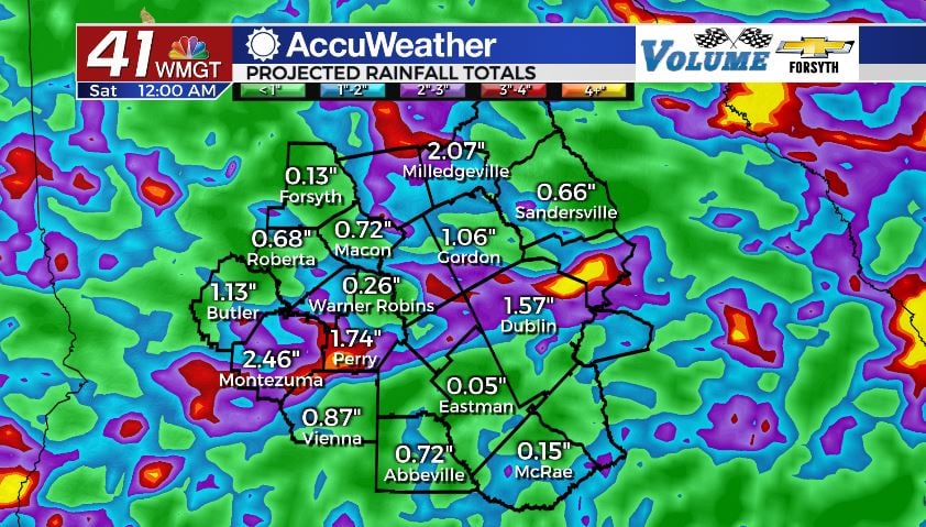
A couple of storms may linger into the overnight hours with a couple more potentially popping up. Overnight rainfall could lead to some patchy fog in some areas around Middle Georgia. Ambient winds will continue to come in from the southwest, this time at 5-10 mph. We could see a shower or two form ahead of the sunrise tomorrow morning as well. Overnight lows will be in the mid 70s, keeping things very humid around Middle Georgia. Rain totals for the day will range from .25” -.75” around the region for those who see storms.
Tomorrow


Rinse and repeat today for tomorrow with a couple of small differences. Highs will be in the upper 80s and lower 90s around the region with heat indices still reaching into the upper 90s and lower 100s. Storm activity will likely be a bit more widespread tomorrow, however, and the amount of rain is anticipated to be greater. These storms will hang around all afternoon and evening. Ambient winds will continue to blow out of the southwest, again at about 5-10 mph.


A few storms will carry into the overnight hours with a few more popping up overnight. Southwesterly winds will continue to feed warm, sticky, and moist air into the Georgia atmosphere, increasing rain chances leading into Friday. Overnight lows will be in the low to mid 70s under overcast skies.
Friday and The Weekend

Friday will continue the current cloudy trend as storm chances continue to hang around Middle Georgia. Highs will be cooler – down into the mid and upper 80s – however heat indices still will reach into the upper 90s as the moisture content in the air continues to thicken. Ambient winds will still come from the southwest. Cloud cover and rain activity should clear out a good bit during the overnight hours into Saturday. Lows will be in the low to mid 70s across the region once again.
The sun will be back for us over the weekend, especially come Sunday. Highs will return to the lower 90s by Saturday afternoon with mid 90s coming back by Sunday. A few isolated storms will be possible in the afternoon both days this weekend. Low temperatures both nights will be in the lower 70s, and ambient winds will continue to blow from the southwest until further notice.

Follow Meteorologist Aaron Lowery on Facebook (Aaron Lowery 41NBC) and Twitter (@ALowWX) for weather updates throughout the day. Also, you can watch his forecasts Monday through Friday on 41NBC News at Daybreak (6-7 a.m.) and 41Today (11 a.m).