Hot and humid conditions return for the new week
MACON, Georgia (41NBC/WMGT) – The sunshine is back for Middle Georgia this week which will lead to more major heat around the region.
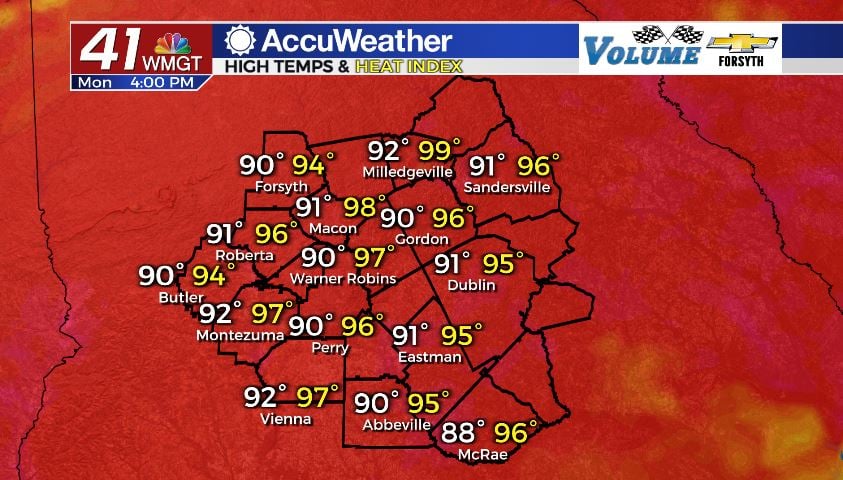
Today
It was a mostly clear but humid morning to kick off our Monday across Middle Georgia. Temperatures were mainly in the lower 70s around the time of the sunrise. Things are heating up rapidly through the mid-morning hours, however. We will see highs in the lower 90s around the region this afternoon, however heat indices will be in the upper 90s. A couple of spots could see feels like temperatures of over 100°, however most should stay below that.

Our storm chances this afternoon are rather low, however one or two stray thunderstorms cannot be ruled out. Later this evening and into tonight, however, a week cold front will be pushing towards our area. It is projected to bring a couple of small storms into our northern counties, however they will subside not long after reaching the area. Most of Middle Georgia will not see those storms.


Once those storms do subside we should be done with rain for the night as skies clear out. A few clouds will likely hang around here or there. Low temperatures tonight will be in the low to mid 70s, and ambient winds will come in from the southwest at 5-10 mph.
Tomorrow
We will begin our Tuesday similar to how we began today: with humid conditions and mostly clear skies. More cloud cover is expected tomorrow, however, especially in the afternoon. Our rain chances are also up tomorrow during the afternoon as a few isolated thunderstorms fire up. Storms may begin to fire up during the early lunchtime hours, slowing the heating process. High temperatures tomorrow will return to the upper 80s for many locations in Middle Georgia due to the added cloud cover and rain. Storms should subside as the sun sets in the evening.


Tomorrow night we will see most of the clouds clear out. Before that happens, however, we could see a couple of lingering storms. Conditions will remain humid overnight as lows drop into the low to mid 70s with dewpoints also remaining in the low to mid 70s. Patchy fog will be possible heading into Wednesday morning.
Wednesday and Beyond
Highs will return to the low to mid 90s come Wednesday afternoon. Skies will be partly sunny as cloud fields develop in the afternoon. A few isolated storms will fire up during the afternoon and the evening. This same forecast also applies to Thursday.
Models are hinting at the possibility of more organized rain activity to move in on Friday, leading to more widespread storms. Highs are still anticipated to reach the lower 90s that day, however, with storms reserved for the late afternoon and evening hours. The pattern will revert to what we see for most of the week once the weekend arrives.

Follow Meteorologist Aaron Lowery on Facebook (Aaron Lowery 41NBC) and Twitter (@ALowWX) for weather updates throughout the day. Also, you can watch his forecasts Monday through Friday on 41NBC News at Daybreak (6-7 a.m.) and 41Today (11 a.m).