

Middle Georgia could see back to back days of severe weather
MACON, Georgia (41NBC/WMGT) – A pair of storm systems could bring severe weather to Middle Georgia Tuesday and Wednesday.
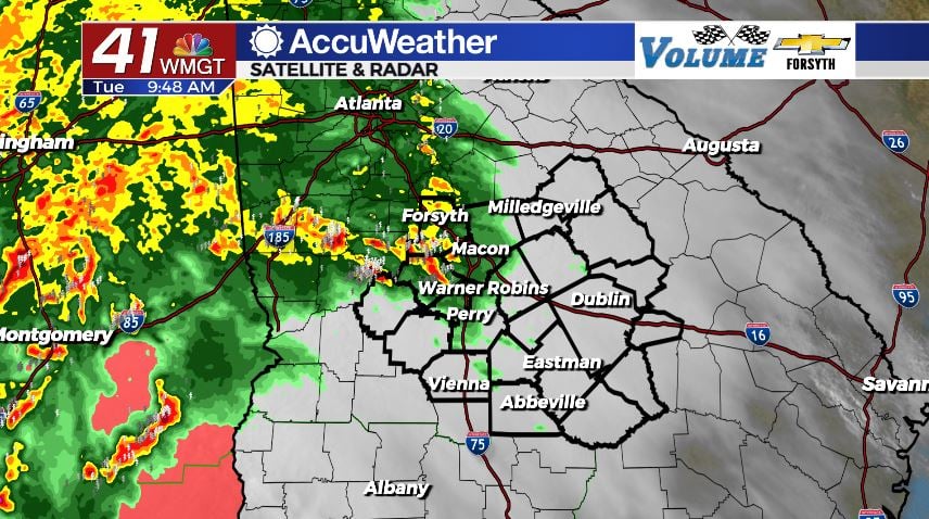
Today
Storms began to enter the western counties of Middle Georgia around 9 am this morning. Rain is likely for most of the region in on and off fashion throughout the afternoon. The worst of the storm activity is expected during the lunchtime hours today. The risk level has not changed from yesterday; it is still a Level 3 “Enhanced” risk for the entire region. Several key ingredients are at play, with an abundance of low level wind shear driving up a tornado threat ahead of the afternoon hours. The good news is the clouds will not be able to clear to allow additional warming, so a powerful push of warm air from the south will be needed to really jump start things. If temperatures can get up into the mid 70s for most of the region, there will be plenty of fuel for storms.


The main cold front is still a ways off in Mississippi, however conditions are likely to become favorable for severe weather by lunchtime. Tornado watches are in effect across all of southern Mississippi and Alabama. It is definitely possible that we see one issued before noon that includes much of Georgia south of I-20. Aside from the tornado risk today, there is also concern for powerful straight line winds associated with downbursts. Winds about 1km off the ground will be blowing at or close to hurricane force much of the afternoon. Heavy downbursts of rain can bring those winds down to the surface, likely resulting in straight line wind damage. Small to medium hail will also be possible as storms fire up this afternoon.


Tonight some weaker storms and showers will persist, however today’s severe threat will drop off ahead of the sunset. It will remain very warm overnight as the winds remain out of the southwest despite a cold front passing. Low temperatures rolling into tomorrow morning will be in the mid 60s. Rain totals by tomorrow morning across the regoin will mainly fall between 1″ and 2″.
Tomorrow
Wednesday brings another threat for severe weather, although the setup is a bit different. We will see afternoon storms fire up in Middle Georgia, once again likely during the lunchtime hours. They will likely fire up a little later than they did on Tuesday, however it should still be early enough to limit potential sunlight. As of now, highs are forecast to be in the upper 70s and lower 80s. All of Middle Georgia is under the Level 2 “Slight” risk for tomorrow afternoon. Models at this time have it looking a bit messy as storms roll through the region, however a couple of those storms could be severe. The greater tornado threat remains off to the north, including the Atlanta area.


The afternoon storm activity will taper off a bit during the evening hours, which could potentially allow some clearing. It shouldn’t be an issue, however, as the sun will either already be setting or close to it by that point. A line of cells (and likely just storms by the time it arrives) will push into Middle Georgia after midnight. By the time they arrive, they will likely be much weaker than they were in the Northern Georgia. They will still carry a small risk of severe, but with temperatures dropping towards the upper 50s ahead of Thursday morning the overall potential should be limited.
Thursday and Beyond
There may be a couple of lingering showers to kick the day off, but other than that the rain train will be leaving us as Thursday begins. There will be plenty of cloud cover early, blocking out the view of the sunrise. By lunchtime, however, the clouds will have mostly left Middle Georgia. Forecast highs are in the low to mid 70s for the afternoon with lows dropping back into the mid to upper 40s.
Friday will see plenty of sun early with cloud fields developing in the afternoon. Highs will be in the mid to upper 60s around the region with lows dropping into the upper 30s and lower 40s, bringing on the annual April cold snap.
Saturday will be the coldest day as highs top off in the low to mid 60s. The European model is again calling for isolated showers on Saturday related to the slow departure of the system to the north, however none of the other models see it and it didn’t rain this past weekend when it called for those showers either. Forecast lows overnight are expected to drop into the mid to upper 30s.

Follow Meteorologist Aaron Lowery on Facebook (Aaron Lowery 41NBC) and Twitter (@ALowWX) for weather updates throughout the day. Also, you can watch his forecasts Monday through Friday on 41NBC News at Daybreak (6-7 a.m.) and 41Today (11 a.m).