Fire threats to persist as the wind shifts to the south
MACON, Georgia (41NBC/WMGT) – Dry conditions with low humidity are expected to persist around Middle Georgia today.
Today


Return flow is finally set to begin across the Peach State as we head into the middle of the week. It all starts with the winds shifting back to the south to transport warm and moist air into Georgia. It takes some time for the humidity to really ramp up, even once the wind has shifted to the south. Earlier this morning the winds were rather calm out of the east-northeast for most of Middle Georgia. Today we will see them shift to the southeast. Speeds are likely to remain below 10 mph with gusts below 15 mph. High temperatures this afternoon will reach into the upper 70s and lower 80s. Sunny skies early are likely to give way to mostly cloudy conditions as we head into the evening hours tonight.


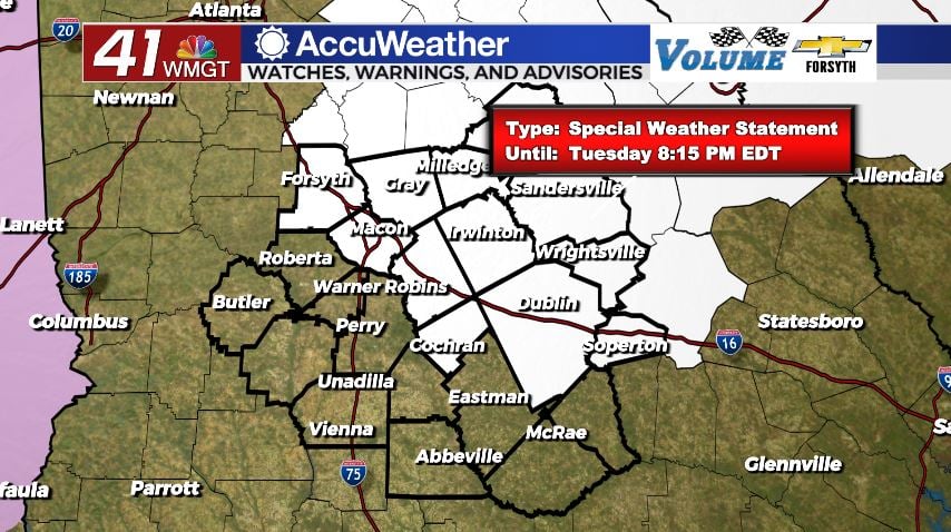
Because it takes time for that humidity to restore, the National Weather Service has again issued a Special Weather Statement in regards to fire weather this afternoon. It includes most of the northern half of the counties in Middle Georgia, however the risk could technically apply to the whole region. Relative humidity values around the region will likely be below 35% this afternoon. Even if the wind is relatively calm, the fact that there has been some haze in the area the past couple of days is enough to prompt the Special Weather Statement.


Tonight humidity will continue to filter into the Peach State as the southeasterly winds pickup in speed to about 15 mpg. Gusts could reach speeds upwards of 25 mph overnight. Cloud cover will continue to thicken as we head towards tomorrow morning. Low temperatures around the region will jump considerably when compared to this morning for much of the region, only dropping into the upper 50s. Some locations could wake up to some patchy fog.
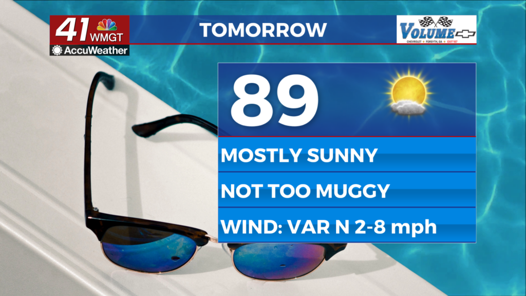
Tomorrow


There will be plenty of cloud cover to begin our Wednesday in Middle Georgia, but conditions will be rather mild. It will be a windy day as well as balmy winds continue to transport more heat and moisture from the gulf. Forecast winds for tomorrow are out of the south at 15-20 mph with gusts over 30 mph. During the afternoon hours we will likely see several pockets of sunshine among the cloud cover. Temperatures will peak in the mid to upper 80s in the afternoon.


As of now there is no advisory or watch/warning related to fire weather for tomorrow, however the SPC has marked all of Northern and Middle Georgia as an elevated risk zone. Humidity values will climb tomorrow thanks to the southerly winds, likely only dropping below 45% during the driest hours of the day. The issue is the fact that the winds will be gusting upwards of 35 mph and that most of the region hasn’t seen rain since last Wednesday. Conditions will unfortunately still be favorable for fires to easily develop and spread, so don’t be surprised if the NWS decides to issue a Red Flag Watch or another Special Weather Statement tomorrow as well.


Overnight tomorrow cloud cover will thicken again after any clearing during the afternoon hours. The winds will continue to gust in at over 30 mph with sustained speeds in the 15-20 mph range from the south. There will be plenty of humidity overnight, but with the strong and warm southerly winds low temperatures will stay rather warm, likely in the mid to upper 60s. This will limit the potential for fog to develop during the early morning hours Thursday. As of now there is a Level 1 “Marginal” threat for severe weather overnight tomorrow night. The storms are likely to arrive during the sunrise hours of Thursday.
Thursday and Beyond


Thursday is our stormy day of the week, and they will waste no time arriving. As of now the Storm Prediction Center (SPC) has issued a Level 2″Slight” risk for severe weather on Thursday. The line of storms is once again looking to arrive during the sunrise hours of the day, which does help to keep the overall severe threats down. It will be a warm morning no doubt as temperatures should still be in the mid to upper 60s from the day before. Storms with the line should clear out of Middle Georgia by lunchtime. It is still unknown as to whether or not scattered afternoon storms are likely or not. If they do occur, that’s when a higher tornado threat would be possible.

Friday will see mostly sunny conditions as the winds returns to the northwest, transporting in cooler and drier air.
Models are still disagreeing on the potential for rain on Saturday, however the one model that has been calling for it (Euro) is beginning to back off. A good amount of clouds are likely Saturday afternoon regardless of whether or not it rains.
Sunday the trend of sunny Sunday’s will continue.

Follow Meteorologist Aaron Lowery on Facebook (Aaron Lowery 41NBC) and Twitter (@ALowWX) for weather updates throughout the day. Also, you can watch his forecasts Monday through Friday on 41NBC News at Daybreak (6-7 a.m.) and 41Today (11 a.m).