Cloudy conditions have returned; severe weather likely tomorrow
MACON, Georgia (41NBC/WMGT) – Cloudy skies are back around Middle Georgia as a new storm system approaches from the west.
Today


A thin layer of clouds filled in over much of the Peach State overnight. This has resulted in much warmer temperatures to begin the day. We will continue to see mostly cloudy conditions today as a layer of high level clouds remains over the region. There may be a few pockets of sunshine, but sunny conditions will likely not be sustained. Highs this afternoon will reach the upper 70s and lower 80s despite the cloud cover. This is largely being driven by southeasterly winds at about 10-15 mph. Gusts could reach speeds upwards of 20 mph today as well. Rain, however, is unlikely during the daylight hours today.


The cloud cover will thicken up a bit more overnight as some lower level clouds build in. Wind speeds will remain at about 10-15 mph however gusts are likely to increase up to speeds of 25-30 mph, still out of the south-southeast. This will keep lows very warm rolling into tomorrow morning, allowing them to only fall into the low to mid 60s. With rain likely moving in ahead of the sunrise tomorrow and severe weather potentially on the horizon tomorrow afternoon, lows could be as warm as the mid to upper 60s. Severe weather is not expected to move in ahead of the sunrise tomorrow at this time.
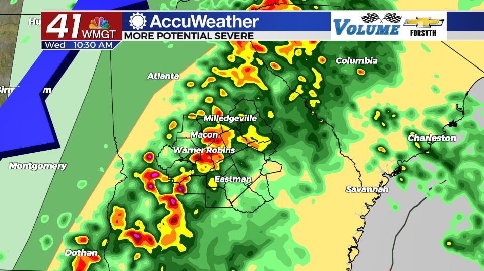
Tomorrow


Accompanying a very warm start to the day will be some moderate to heavy rain with some thunderstorms. You’ll want an umbrella out the door as there will be plenty of rain chances tomorrow with the first wave arriving early and a second around lunchtime. It’s that second wave that is bringing the severe weather threat as temperatures climb back into the low to mid 70s. Winds will continue to come in from the south and south-southeast at about 15-20 mph with gusts in excess of 30 mph possible ahead of afternoon storm activity.


The severe weather threat is a Level 2 “Slight” for all counties in Middle Georgia at this time. This could elevate into a Level 3 “Enhanced” risk ahead of tomorrow morning. As of now the main risks look to be strong winds and heavy rain, but the tornado threat looks higher than in previous systems. Winds at the surface will be from the south/south-southeast but winds about 1km above the surface will be out of the southwest at 50-80 mph. This hints at the possibility of high levels of low-level shear (change of wind direction and speed with height) which favors a higher tornado threat. If that doesn’t pan out, those winds that are 1km aloft could also be brought down to the surface by heavy downbursts of rain. These very powerful straight-line wind gusts could blow over trees and power lines causing property damage.


The storms will subside in the late afternoon hours, leaving mostly cloudy conditions rolling into tomorrow night. A few showers will be possible around the region tomorrow night as the cloud cover remains overhead. The wind should also slow down to under 15 mph as it shifts more towards the west overnight. Lows will cool a bit from Tuesday night back into the mid 50s.
Thursday and Beyond

Some sunshine is likely to return on Thursday however a few isolated showers will also be possible in the afternoon. Those will just be an after-effect of the storm system as it continues to push northeast.
Friday will see the return of more sun but scattered clouds are likely to develop in the afternoon. Rain is unlikely with these clouds.
Overall sunny conditions along with strong breezes will dominate the weekend, especially on Saturday.

Follow Meteorologist Aaron Lowery on Facebook (Aaron Lowery 41NBC) and Twitter (@ALowWX) for weather updates throughout the day. Also, you can watch his forecasts Monday through Friday on 41NBC News at Daybreak (6-7 a.m.) and 41Today (11 a.m).


