Showers likely around Middle Georgia Thursday; more severe weather possible Friday night
MACON, Georgia (41NBC/WMGT) – Scattered showers are likely early Thursday and again overnight, and another cold front could bring a severe weather threat Friday night.
Today


The pattern of mild, cloudy, and humid mornings continued today around Middle Georgia. The cloudy skies will stick with us again throughout the day today, however the rain chances will drop off after lunchtime. Until then, scattered showers will remain possible around the region with the southern counties seeing the highest probability for shower activity. The afternoon will stay rather mild as temperatures peak in the mid to upper 60s. Winds will be variable around 5 mph as we go through the daylight hours. A few southwestern counties could see a bit of sun later this evening, but cloud cover overall will dominate into tonight.

Overnight we will see some clearing of the clouds early, but they will build back in ahead of the sunrise tomorrow. Shower activity could ramp up a bit in the southern counties during the overnight hours as well, but much like this morning, they will be very scattered. Low temperatures heading into tomorrow morning will be in the upper 40s and lower 50s. Winds will blow in from the east-northeast at around 5 mph.
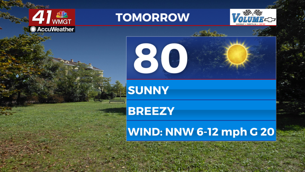
Tomorrow


The forecast for Friday is again a cloudy one, however this is good news given the severe weather threat. The other good news is a lot of shower activity is expected in the southern counties of the region, which happens to be where the severe threat is highest. Shower activity ahead of severe weather almost always limits the potential, and when the threat is overnight like it is tomorrow, it’s always good to see the threat level drop. Highs in the afternoon will likely reach the upper 60s and lower 70s. The wind will come in from the east-southeast at 5-10 mph.


Tomorrow night is when the severe threat will arrive, just ahead of a powerful cold front. Winds will pick up drastically, initially blowing in from the southwest at 10-15 mph but increasing to about 25 mph ahead of the front. Gusts ahead of the front could reach up to 40 mph. As of now the severe threat is a Level 2 “Slight” Risk, and given the conditions, this seems appropriate. The temperatures outside will be on the cooler side when the strong storms begin to fire up, limiting potential. However, because they are occurring at night, that makes these storms extra dangerous.


The risk overall for tornadic activity is low, however it is not zero. The primary risk with tomorrow night’s threat will be strong wind gusts, as the powerful front will likely bring a powerful squall line with it. The wind will shift to the northwest after the front passes, but speeds will remain strong, ranging from 15-25 mph with gusts upwards of 40 mph. Low temperatures will respond accordingly, dropping back down into the 30s for the first time in weeks.
The Weekend


We will see the return of sunshine for the first time since Monday on Saturday. The cold front should be out of Middle Georgia by the time the sunrise on Saturday arrives, however a few clouds will likely still remain. These should all be gone ahead of the lunchtime hours. The cold front is not leaving quietly, however. Even if the severe threat does not pan out (and let’s hope it doesn’t), the powerful winds in it’s wake will make sure you know it came through. Sustained speeds will range in the 20-30 mph range with gusts potentially reaching 45 mph. These winds will not only bring some cold chills (potentially 10 degrees or more below the actual temperature), but anyone travelling may notice difficulty in keeping their vehicle aligned. Temperatures in the afternoon will peak in the low to mid 50s, however as mentioned above it likely won’t feel that nice, even with the return of sunny skies.

Sunday will see sunshine dominate all day as highs reach the mid to upper 50s. The winds will shift back to the southwest ahead of Sunday afternoon, immediately beginning to return heat and humidity to the Georgia atmosphere following Friday night’s cold front.
Monday should still see a good deal of sun, but the humidity will be more pronounced and highs will be back in the mid to upper 60s. Rain chances will begin to return overnight with shower activity looking likely on Tuesday and Wednesday.

Follow Meteorologist Aaron Lowery on Facebook (Aaron Lowery 41NBC) and Twitter (@ALowWX) for weather updates throughout the day. Also, you can watch his forecasts Monday through Friday on 41NBC News at Daybreak (6-7 a.m.) and 41Today (11 a.m).