Heavy rain moving into Middle Georgia tonight could bring flash flooding
MACON, Georgia (41NBC/WMGT) – A cold front will bring heavy rain and strong winds to Middle Georgia tonight and much of tomorrow.
Today


Cloudy skies will dominate the Peach State again today as a massive storm system continues to slowly trek eastward across the US. Rain will slowly make its way southeastward through the state today, but all Middle Georgia should see during the daylight hours are isolated showers. Today will be the warmest day of the week despite the cloud cover, reaching highs in the upper 70s. Strong winds out of the south are a large factor in the excessive warmth and humidity. Sustained wind speeds today will be in the 10-20 mph range with gusts in the 25-30 mph range.


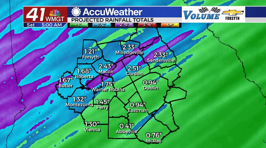
Overnight conditions will remain warm thanks to the warm front driving southerly winds. The cold front will begin to move into the region ahead of midnight, bringing heavy rain and some strong wind gusts from the northwest. Rain accumulations will increase rapidly during the overnight hours around Middle Georgia, especially in the northern counties. Totals from the overnight hours tonight will likely fall between 1 and 2 inches in much of Middle Georgia. Thanks to the slow moving nature of the cold front, severe weather is not a concern, however flash flooding will be possible in low lying areas due to high rainfall rates. Conditions will also stay warm into tomorrow morning as lows only fall into the low to mid 60s.
Tomorrow


Cloudy skies remain over Middle Georgia for a third day in a row as temperatures slowly cool. Highs will reach the upper 60s around the region with winds blowing out of the northwest at about 5-10 mph. Scattered showers of light to moderate rainfall are likely throughout the day on Saturday with some lingering into the overnight hours.


Rainfall should clear out by midnight Friday night with cloud cover breaking up leading into Saturday morning. Low temperatures will return to a more seasonable feel, falling into the upper 30s and lower 40s.
The Weekend

Saturday will be the pleasant day of the weekend as clear skies return to the Peach State. High temperatures will reach the mid to upper 50s around Middle Georgia as the wind blows in from the northeast at 5-10 mph. Cloud cover will begin to return during the evening hours.
Overnight cloud cover will continue to increase, especially in the southern counties of the region. A couple of isolated showers will also be possible in the southern counties to accompany the cloud cover. Lows around the northern half of Middle Georgia will fall into the low to mid 30s while those who receive more cloud cover will remain a few degrees warmer.

Sunday will see a blanket of clouds over the southern half of Georgia with scattered showers during the afternoon. Highs will reach the lower 50s with winds still out of the northeast. This pattern will likely persist into Monday thanks to a weak system off the Atlantic Coast of Florida and the Georgia Bight.

Follow Meteorologist Aaron Lowery on Facebook (Aaron Lowery 41NBC) and Twitter (@ALowWX) for weather updates throughout the day. Also, you can watch his forecasts Monday through Friday on 41NBC News at Daybreak (6-7 a.m.) and 41Today (11 a.m).


Leave a Reply