Sun and warmth hang around for the first day of February
MACON, Georgia (41NBC/WMGT) – Temperatures are returning to the upper 60s this afternoon around Middle Georgia.
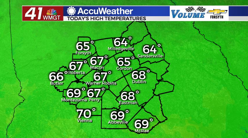
Today


The first morning of February was a cold one with more than half of Middle Georgia kicking the day off with sub-freezing temperatures. Considering that February is the dead of winter, this is not surprising. What is surprising, however, is how warm the region is this week. Sunny skies will stick around today, allowing peak temperatures to reach the mid to upper 60s. Winds blowing in from the east-southeast at 5-10 mph will also add a bit of heat and moisture. Cloud cover will be at a minimum until tonight; we should only see a few cirrus clouds here and there.


Overnight cloud cover will begin to build leading up towards Wednesday morning. We likely will not have a complete blanket overhead by the time the sun rises tomorrow, however there will be enough insulation to increase our low temperatures to the lower 40s. Depending on how thick the clouds end up being, lows could drop into the upper 30s. The wind will blow from the east at 5-10 mph.
Groundhog Day


Groundhog day will be a relatively cloudy one around the Peach State, however that doesn’t mean it won’t be warm. Highs will continue to climb, this time topping off in the lower 70s for most of Middle Georgia with the northern counties climbing into the upper 60s. The wind will provide a warm breeze throughout the day as it blows from the southeast at 10-15 mph with gusts over 20 mph. There is a slim chance for a couple of very small, stray showers during the afternoon, however most of us will stay dry.


Overnight cloud cover will thicken more as a large system develops over the Mississippi River Valley and begins to move east. Overnight lows will be warmer than some highs from last week as we only fall into the 50s.
Thursday and Beyond


Rain chances will increase further on Thursday, however during the daylight hours we likely will only see a few isolated showers around Middle Georgia. The eastern counties in the region look to have the highest chance to see them as of now. Highs will reach the mid to upper 70s around the region as a warm front moves though the southeastern US. Winds will be rather breezy with sustained speeds of 10-15 mph and gusts over 20 mph, coming from the south-southeast.

Overnight a cold front will push into the region, bringing heavy rain, some strong gusts, and a few rumbles of thunder. Once the initial front passes the rain will lighten up, however it will be persistent. Rain will stick around the region into Friday afternoon, so anyone with outdoor plans may want to reconsider. At this time severe weather is not expected, however given the amount of heat in the atmosphere ahead of the cold front there could be some powerful wind gusts. Highs on Friday will likely be in the upper 60s around the region.
Friday night should see most of the cloud cover clear out heading into Saturday for a quick break from the rain.
Saturday looks to be sunny with highs in the upper 50s. Clouds will return during the evening with rain likely again overnight and into Sunday.
Sunday will see the rain leftover from Saturday night hang around into the afternoon hours as highs reach the lower 50s. Sunshine should return on Monday.

Follow Meteorologist Aaron Lowery on Facebook (Aaron Lowery 41NBC) and Twitter (@ALowWX) for weather updates throughout the day. Also, you can watch his forecasts Monday through Friday on 41NBC News at Daybreak (6-7 a.m.) and 41Today (11 a.m).


Leave a Reply