


Rain returns to the forecast in Middle Georgia
MACON, Georgia. (41NBC/WMGT) – Rain chances are rising heading towards the weekend in the Peach State.
Today
It was a much warmer start around Central GA thanks to a blanket of clouds that rolled in overnight. Low temperatures from yesterday ended up only reaching the mid to upper 40s for most of the region and some of us didn’t drop below 50. A few small showers also fired up around sunrise in some of the eastern counties, but those have already faded. The clouds will clear heading towards lunchtime with sunshine sticking with us the rest of the day. Temperatures around Middle GA will reach the low 60s this afternoon with westerly winds at 5-10 mph. One or two spots may not reach the 60 degree mark, such as Forsyth.


Overnight the skies will remain mostly clear as the winds briefly shift to the northwest at around 5 mph. Without the insulation of cloud cover low temperatures should fall back into the upper 30s and lower 40s across the region.
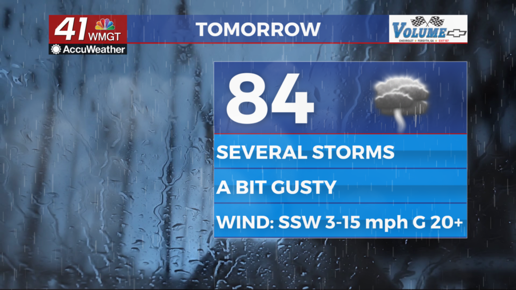
Tomorrow
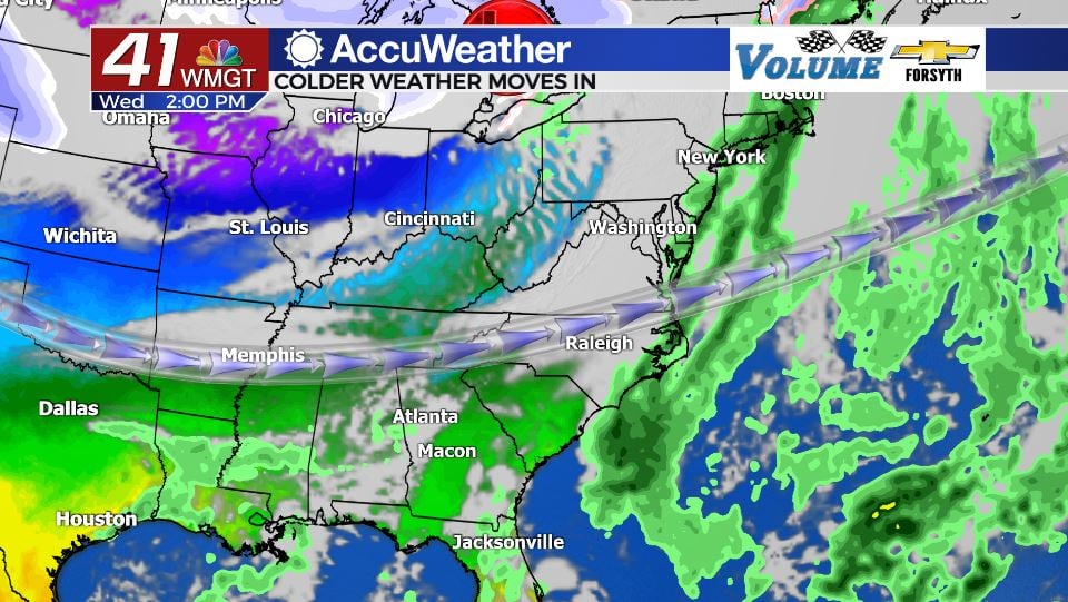
A clear start will ultimately give way to a mostly cloudy afternoon ahead of a cold front Thursday night. A few spotty showers are possible during the afternoon hours, but the majority of the rain will arrive with a cold front during the early overnight hours. High temperatures in the afternoon should reach the low to mid 60s with winds out of the south-southwest.


Not a lot of rain is expected with the cold front as it arrives as the system is expected to be quite weak. Some locations in Middle GA may only see some light rain out of this or nothing at all, especially further south. Low temperatures overnight will fall below freezing across the board as cloud cover clears heading into Friday morning.
Friday and Beyond
Friday will be very similar to Monday with overall benign conditions expected. There will likely be some chilly breezes out of the north-northwest, but unlike Monday gusts shouldn’t clock in over 20 mph. High temperatures will only reach the upper 40s and low 50s following the cold front’s passing as cool and dry air fills in to Georgia. The skies will stay clear overnight as temperatures fall below freezing again heading into Saturday morning.

Saturday will see mostly sunny skies as well as temperatures jump back into the upper 50s. Rain is not expected as winds shift back to the east at 5-10 mph. Cloud cover will begin to fill in overnight ahead of a warm front on Sunday. Lows will fall into the upper 30s and lower 40s heading into Sunday morning.
Sunday will warm up quite quickly as a warm front moves through. This will warm highs into the upper 60s and lower 70s ahead of a late cold front that could bring rain in all afternoon and evening. At this time severe weather is not expected.
Cooler weather should continue to hang around into next week.

Follow Meteorologist Aaron Lowery on Facebook (Aaron Lowery 41NBC) and Twitter (@ALowWX) for weather updates throughout the day. Also, you can watch his forecasts Monday through Friday on 41NBC News at Daybreak (6-7 a.m.) and 41Today (11 a.m).


Leave a Reply