


Cold front to bring heavy rain to parts of Middle GA
MACON, Georgia. (41NBC/WMGT) – Heavy rain is likely in parts of Middle GA early before scattered showers become possible for others later.
Today
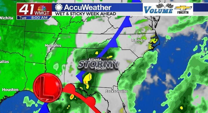
It’s a wet start in parts of Georgia, but for much of Middle GA nothing has happened yet. The cold front is slowly pushing its way eastward, and at about 8:30 am today the heaviest rain began to push into Monroe, Taylor, and Crawford Counties. These three counties along with Bibb and Jones are under a Flash Flood Watch until 2 am Thursday largely because of this cold front. These thunderstorms will persist through the morning hours, likely pushing as far eastward as Bibb, Macon, and Peach Counties and potentially reaching Houston and Dooly Counties as well. The reason it won’t reach everywhere in Middle GA is because the cold front is going to stall and fizzle out. This doesn’t mean the other counties are in the clear, it just means the heavy rain won’t get there early. Scattered storms are expected for much of the region this afternoon, and there could be some localized heavy rainfall with them.
Those of us in Middle GA affected by the heavy rainfall early will see cooler conditions this afternoon than those of us who aren’t. High temperatures in cities such as Butler and Forsyth will top off in the lower 70s. Macon is likely to fall into this category as well. Meanwhile, locations further east such as McRae and Dublin will likely climb into the upper 70s and lower 80s this afternoon. Cloud cover will not budge throughout the day and will linger into tonight. The scattered storms that fire up during the afternoon will also persist into the overnight hours. Low temperatures across Middle GA will be in the upper 60s and lower 70s.
Tomorrow
The cold front will be out of our hair by the afternoon hours of today, but the Peach State is anything but in the clear in terms of rain once it passes. A low pressure system coming from the Gulf of Mexico will slowly move northward, bringing an abundance of moisture with it. A warm front associated with that low will move through Georgia tomorrow and Thursday, bringing plenty of rain but not much in terms of thunder. Temperatures will rebound in cities like Macon tomorrow back to the upper 70s, closing the range of highs around Middle GA. During the early half of the day rain will only be seen by a few, however widespread showers are likely during the afternoon and evening hours. These will persist into the overnight hours and fizzle a bit overnight. Low temperatures will again be in the upper 60s around the region.
Thursday and Beyond
The warm front will continue pushing northward on Thursday, however by that point it will mostly be north of GA. This will leave an opportunity for some isolated showers, but overall rain totals should be lower for Thursday than any day so far this week. Temperatures will again climb a degree or two around the region, topping off in the upper 70s and lower 80s under mostly cloudy skies. Even with the warm front passing, however, we still will not be out of the woods quite yet. The cold front associated with the low from the Gulf will make its way into GA from the west come Friday. This will bring another round of thunderstorms to at least some parts of Middle Georgia, likely early on Friday. Once the weekend arrives, a bit more sunshine should finally return to the forecast. Rain chances will still persist through the weekend, however not nearly as widespread.

Follow Meteorologist Aaron Lowery on Facebook (Aaron Lowery 41NBC) and Twitter (@ALowWX) for weather updates throughout the day. Also, you can watch his forecasts Monday through Friday on 41NBC News at Daybreak (6-7 a.m.) and 41Today (11 a.m).


Leave a Reply