
One more extremely hot day before relief arrives by the end of the week
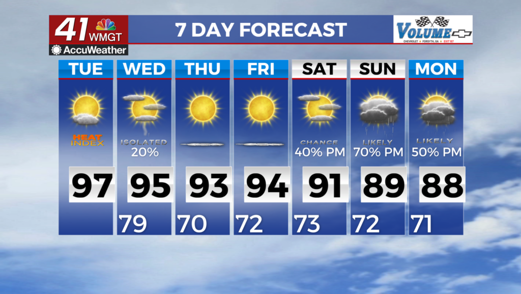
MACON, Georgia (41NBC/WMGT) – Today sees the upper level ridge slide ever so slightly to the east which is very unfortunately for our temperatures and humidity. Heat builds into the area 


with mostly clear skies. High will be in the 90s. Dewpoints will be in the 70s. Misery will be experienced by all. A Heat Advisory has been issued for portions of north and Middle Georgia from noon through 8 PM Tuesday. Please take caution if working, exercising, or playing outdoors. Take frequent breaks and drink plenty of liquids. A jet streak embedded within the northwest flow of the upper level ridge/trough is expected to kick off some convection north of the area this afternoon/evening. Models are pretty uniform in seeing organized storms form and push south, potentially clipping portions of Northeast Georgia by the late evening to early overnight. Where things diverge is in how well these organized storms hold together. Various models dissolve it before it arrives into the coverage area, others keep it into Northeast Georgia before quickly falling apart, and others keep it together into parts of Atlanta. Some models are even showing convection 


pushing into North Georgia. There will still be plenty of instability in place. Shear will once again be the limiting factor. The main takeaway is that uncertainty is high around just how far south these storms get, but where they do hold together, expect to have a chance of some severe weather. The primary threat will be damaging wind gusts up to 60 mph. By Wednesday morning, a cold front moves south into North Georgia and pushes rapidly through our area. We are expecting a line of showers and thunderstorms to develop with this front and move south through the day Wednesday. A few of these storms may be strong and capable of producing gusty winds, frequent lightning strikes, and periods of heavy rain. We are currently under a Marginal Risk across 

portions of Middle Georgia so we will keep an eye on how things develop as we get closer to Wednesday. With the front moving through the area during the day we will also have the diurnally driven instability to deal with and things trailing off after sunset. The models show this front moving south of the area Thursday with a much drier airmass moving in behind it. Drier air associated with a high pressure ridge builds southeast out of the Western Great Lakes states will clear things out for North and Middle Georgia Thursday/Friday. Temperatures are not expected to cool too much with high temps still expected in the upper 80s to middle 90s but the Real feel temperatures will be much lower.