Storm chances remain elevated this weekend
MACON, Georgia (41NBC/WMGT) – A stationary front followed by a surface trough and a cold front will lead to storm odds through the coming weekend and early next week.
This Evening and Overnight
Overcast skies will stick with Middle Georgia through the uneven and into tonight as rain showers creep up from the southwest. While the odds for rain will likely remain low until late this evening off and on activity is expected through the overnight hours. Thunder and lightning are unlikely with rain tonight however the occasional bolt or rumble of thunder can’t be ruled out. Temperatures will drop to around 60 degrees across Middle Georgia as the wind flows from the southwest-southwest around 5 mph.
Tomorrow
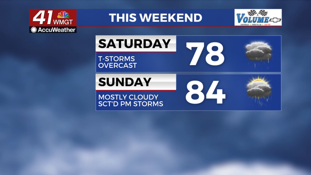
Rain showers will likely be ongoing as the sun rises Saturday morning with thunderstorms likely moving into Middle Georgia ahead of lunchtime. The most intense storms will likely be the first ones seen during the day with the southern counties of Middle Georgia currently included in a Level 1 “Marginal” threat for severe storms. The primary risk is a few damaging wind gusts, however a bit of hail is also possible. These storms will be off and on throughout the afternoon and evening.


Aside from the wet conditions it will be a bit below average with highs expected in the upper 70s and lower 80s. Skies will remain overcast throughout the day as ambient wind flows from the west-southwest at around 5-12 mph. Gusts could reach as high as 20 mph and even higher with storms.


Overnight some showers and storms will linger early, however all activity should cut off before the sunrise Sunday morning. Temperatures will valley in the lower 60s across the region as the wind flows from the southwest around 5 mph.
Sunday and Beyond
Some sunshine is expected to return on Sunday before more clouds fill in during the afternoon. Temperatures will climb into the mid 80s across the region accompanied by light and variable winds. Scattered storms are likely during the late afternoon and evening hours carrying into Sunday night. Severe activity is unlikely although at this time the far southwestern counties of Middle Georgia (Crisp and Wilcox) are included in a Level 1 “Marginal” threat for Sunday afternoon/evening.

Another cold front will arrive Monday and bring another round of storms across Middle Georgia. There could be a low end severe threat to go with this with the primary threat being a few damaging wind gusts. Sunshine is forecast to return Tuesday afternoon.

Follow Chief Meteorologist Aaron Lowery on Facebook (Aaron Lowery 41NBC) and X (@ALowWX) for weather updates throughout the day. Also, you can watch his forecasts Monday through Friday on 41NBC News at 4, 5, 5:30, 6, and 11 p.m.