Dense fog and above normal temps start the new week
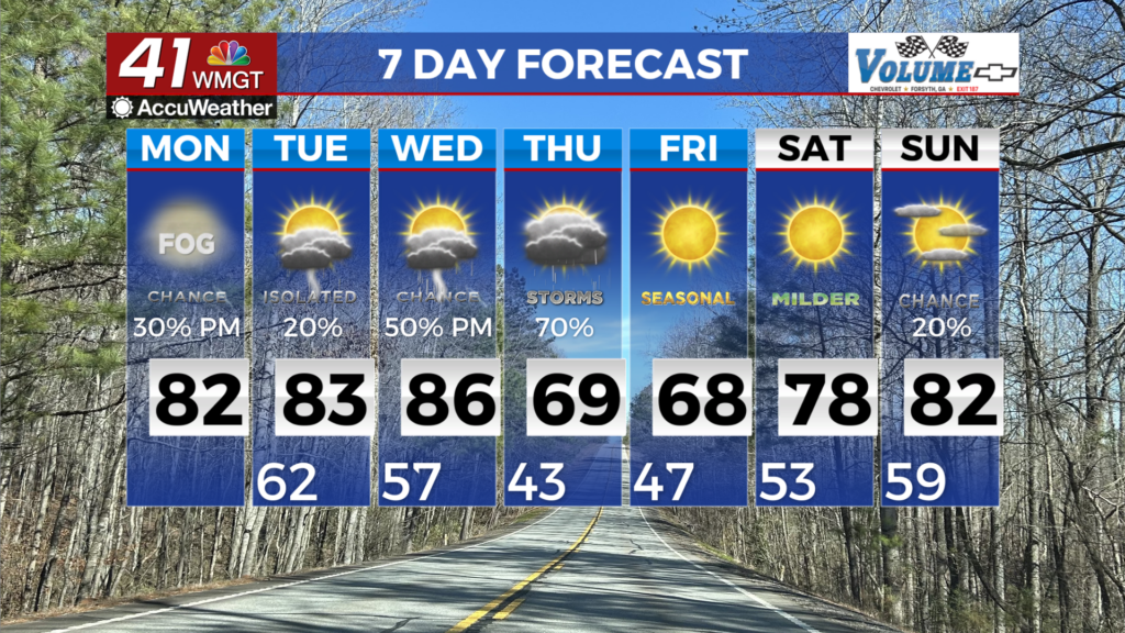
MACON, Georgia (41NBC/WMGT) – Low clouds and areas of fog start off Monday morning before dissipating by midday, leading to partly cloudy afternoon skies. With more widespread sun 


on Monday, high temperatures will again rebound into the upper 70s to low 80s. The focus then shifts to an approaching mid-level shortwave riding eastward across the Lower Mississippi Valley by the afternoon. This wave initiates thunderstorms across to the west that will progress eastward through Monday evening, likely forming organized clusters. Some of this activity is expected to weaken before approaching portions of the area heading into Monday night. At the start of the extended forecast on Tuesday, the Southeast remains entrenched within an unseasonably warm and moist airmass fueled by multiple days of southwesterly flow routed along the western edge of persistent high pressure. Daily chances for showers and thunderstorms will continue through midweek, with any disturbances passing through the zonal flow increasing the coverage. Warm temps and moisture will support efficient rainfall. A brief but meaningful pattern change looks to come Wednesday into Thursday, when a stronger cold front riding along the leading edge of a broader trough sweeps eastward. Showers and thunderstorms are likely to be more widespread and perhaps more organized along the front, and the highest rain chances look to come on Thursday as the bulk of the frontal forcing passes through. Post-front we return to a schedule of high pressure and abundant warmth through the weekend and more notably, a lack of diurnal rain chances to round out the work week.